Agriculture forms the backbone of Pakistan’s economy, with wheat being the most extensively cultivated crop, occupying over 9 million hectares of land and providing more than 72% of the daily caloric intake for the majority of the population. Despite its significance, wheat production in Pakistan faces numerous challenges, resulting in yields that remain below their potential. In the 2022-2023 crop year, Pakistan had an average wheat yield of 3.12 tonnes per hectare, that was below the global average at 3.55 tonnes per hectare. This underperformance underscores the urgent need for innovative solutions to optimize agricultural practices and enhance food security.
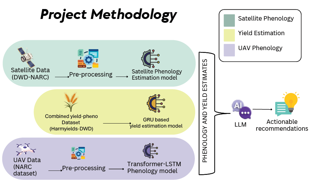
WheatInsight addresses these challenges by developing a comprehensive phenology and yield estimation system for spring wheat that leverages cutting-edge technologies in remote sensing and artificial intelligence. Wheat crops require special care and certain actions under each phenological stage. WheatInsight provides these actionable recommendations for your crop at each particular stage. The system offers two separate specialized pipelines: one utilizing high-resolution UAV imagery for field-level precision, and another employing broad-coverage satellite data for more large-scale monitoring. This approach enables WheatInsight to serve the diverse needs of both stakeholders who need precise insights, and stakeholders that prefer inexpensive and more broad insights into their crop’s phenology.
The system employs advanced deep learning techniques, including vision transformers and LSTM networks, to process temporal and spatial data for accurate phenology stage classification. For field-level analysis, our UAV-based module achieves over 90% accuracy in classifying wheat growth stages, generating detailed overlay maps that visualize phenological progression across fields. Complementing this, our satellite-based module processes multi-spectral Sentinel-2 data to provide district-wide monitoring capabilities, currently achieving close to 90% accuracy with ongoing improvements.
WheatInsight’s modular, object-oriented architecture ensures scalability and maintainability, while the Agile development methodology accommodates evolving requirements throughout the project lifecycle. The system features a user-friendly web interface with interactive visualizations such as an interactive heat map for field phenology for both UAV and satellite views, as well as a recommendation section to present users interpretations and suggestions based on the data. By delivering in-season and accurate phenology estimation and yield prediction for spring wheat and giving actionable recommendations based on it, WheatInsight aims to introduce smart agriculture practices for spring wheat in Pakistan. The system not only supports individual farmers in optimizing resource utilization and managing yield but also contributes to broader agricultural planning and food security initiatives. WheatInsight is a step towards the application of modern and sustainable agricultural practices in Pakistan, contributing directly to the UN SDGs 2,12 and 13.