
Domain Generalization in Satellite-Based Crop Mapping
This project addresses one of the most pressing challenges in agricultural remote sensing: how to create reliable and generalizable models for crop type classification that remain effective across diverse geographies, seasons, and sensor platforms. Traditional crop mapping methods often fail when applied outside the specific region or season they were trained on, largely due to variations in soil reflectance, atmospheric conditions, crop management practices, and the differences between satellite sensors. This project seeks to overcome these limitations by focusing on the spectral signatures of crops, which are unique biochemical and physiological reflectance patterns observed throughout the growing season. By leveraging transfer learning and domain generalization strategies, the project aims to build robust models that can adapt to unseen environments while minimizing the need for costly and time-consuming ground truth data collection in every new region. The ultimate vision is to make crop mapping models more scalable, practical, and impactful for precision agriculture, food security monitoring, and climate resilience studies.
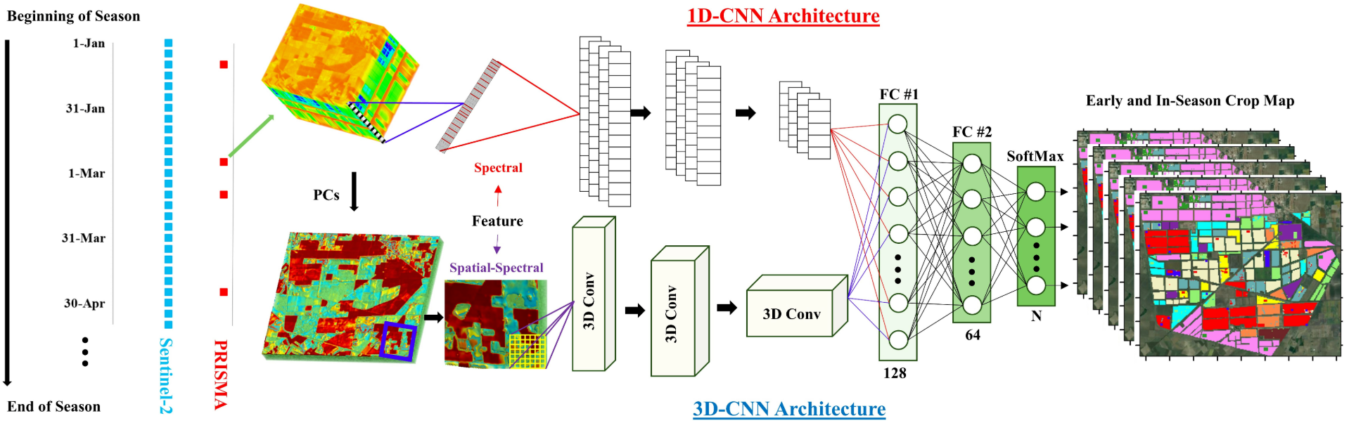
We combine advanced machine learning techniques with domain-specific agricultural knowledge. Using time-series satellite imagery, the spectral dynamics of crops such as wheat, rice, maize, and cotton are captured across different phenological stages. These temporal reflectance patterns are then processed into discriminative feature spaces that form the foundation for training crop classification models. Transfer learning is employed to reuse knowledge from existing datasets, while domain generalization approaches ensure the models remain resilient to shifts in location, season, or satellite sensor. For example, models trained on Sentinel-2 imagery in North American or European wheat-growing regions can be adapted to classify maize or wheat in South Asia, without retraining from scratch. Beyond just classification, the system also accounts for spectral overlap between crops and background vegetation, ensuring that the resulting crop maps are not only accurate but also temporally consistent. Such advancements are particularly critical for in-season mapping, where timely insights can directly inform government decisions, farmer advisory systems, and resource allocation during critical growth stages.

This work directly supports global priorities in agriculture, sustainability, and food systems management. By making crop mapping models more transferable and generalizable, the project reduces dependency on region-specific labeled datasets, lowering barriers for adoption in data-scarce regions. This opens new opportunities for governments and organizations in developing countries to monitor crop distribution and production in near-real time, even when they lack extensive ground-truth data infrastructure. Furthermore, the project has strong potential for integration with climate-smart farming initiatives, where understanding the spatial distribution of crops is essential for yield estimation, drought monitoring, and early warning systems. By advancing the scientific understanding of crop spectral signatures and embedding them into domain-robust machine learning frameworks, the project sets the stage for globally scalable crop monitoring pipelines. It empowers stakeholders at every level, from policymakers to individual farmers, by enabling accurate, adaptable, and timely crop intelligence derived from space-based observations.
Faculty
-
Dr. Muhammad Moazam FrazDr. Muhammad Moazam Fraz
-
Dr. Zuhair ZafarDr. Zuhair Zafar
Students
-
Mamoona Qudsia