
Mapping Development & Consumption Through Nighttime Lights
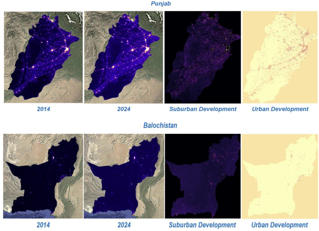
The aim of this project is to harness the power of satellite-derived nighttime light data to understand the relationship between electricity consumption, economic activity, and patterns of urbanization across regions. Over the past decade, nighttime light imagery captured by VIIRS (Visible Infrared Imaging Radiometer Suite) and DMSP-OLS (Defense Meteorological Satellite Program – Operational Linescan System) has emerged as a reliable proxy for human activity, industrial development, and socio-economic growth. This project builds upon that foundation by developing advanced methods for quantifying light intensity as an indicator of electricity consumption, infrastructure density, and population distribution. By integrating remote sensing with geospatial analytics, the project will identify regions of high and low consumption, map disparities in energy access, and track the pace of urban expansion, thereby providing an evidence-based understanding of development dynamics. Beyond simple correlations, the study will also focus on how variations in light intensity reveal patterns of inequality, such as rural underdevelopment and uneven distribution of resources, which are often missed in conventional economic surveys.
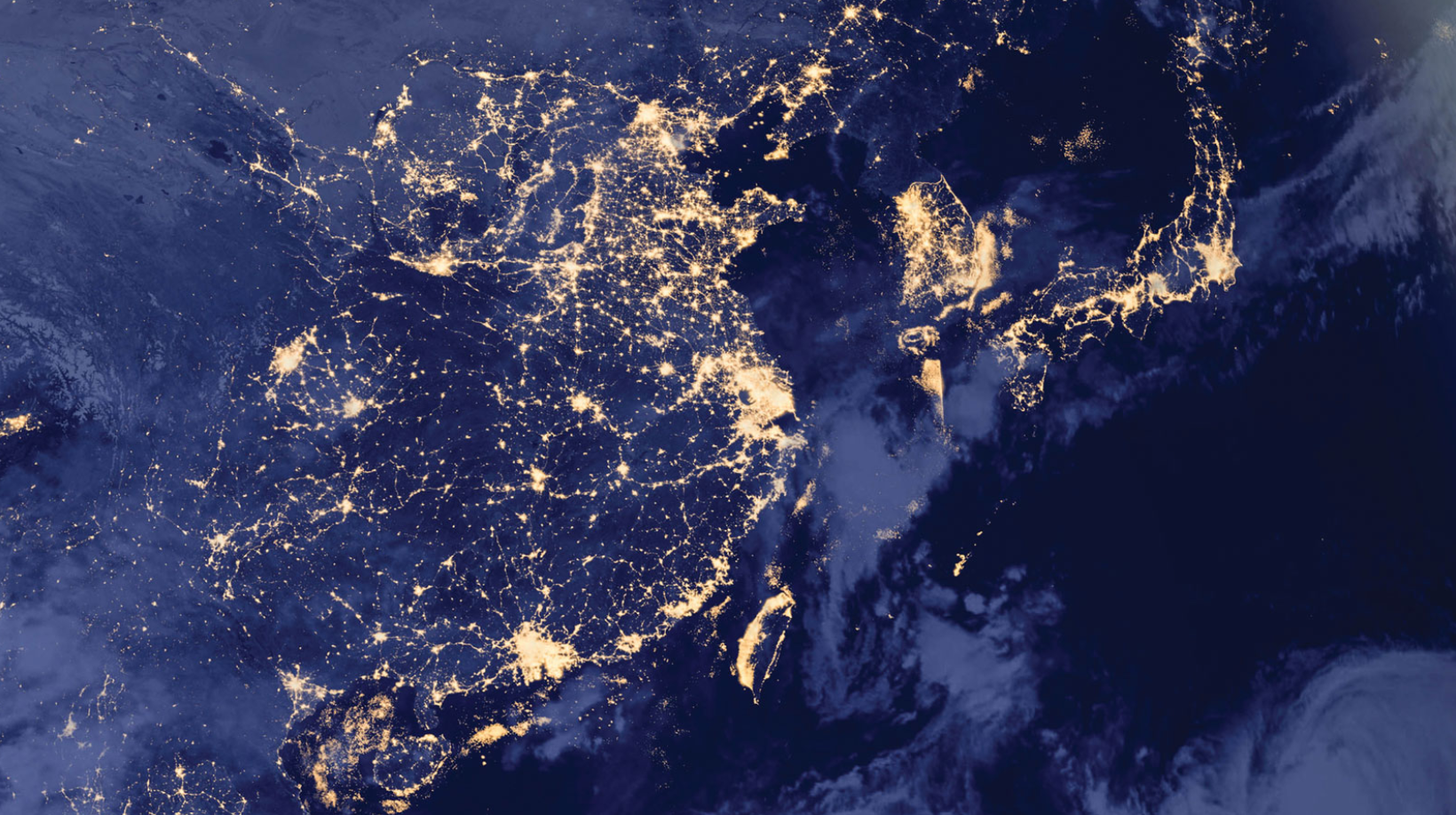
We use nighttime light intensity as a non-traditional but highly effective tool for economic mapping and monitoring GDP at regional and sub-regional scales. Traditional metrics of gross domestic product rely heavily on surveys, government reporting, and statistical models, which may be delayed, incomplete, or limited in spatial resolution. In contrast, nighttime lights offer continuous, objective, and globally comparable datasets that directly capture human activity patterns and their energy footprints. This project will create models that link calibrated light intensity with regional GDP values, industrial clusters, and service-sector hubs, thereby enabling near real-time monitoring of economic performance. Moreover, the analysis will extend to understanding how development is distributed geographically: are high levels of light concentrated in urban megacities, or do they reflect more dispersed growth across smaller towns and semi-urban regions? This perspective allows for a richer understanding of spatial inequality and economic resilience, particularly in developing economies where official statistics may lack granularity. The project also seeks to integrate nighttime light data with other spatial layers such as land use, road networks, and census datasets, enabling a multidimensional analysis of how energy consumption and development interact with infrastructure and population distribution.
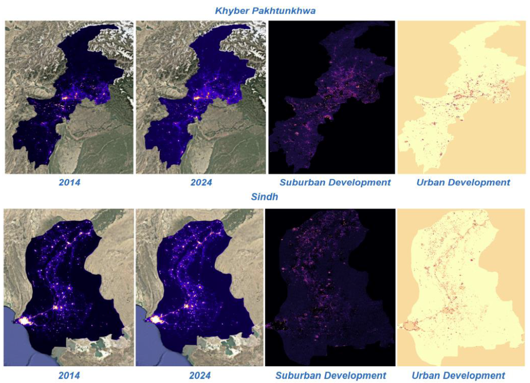
This work project emphasizes its policy relevance and practical applications for sustainable planning and governance. Governments and urban planners often struggle with uneven electricity distribution, unmonitored urban sprawl, and limited insights into energy poverty. By leveraging nighttime light data, this project will provide actionable intelligence for identifying underserved regions, planning new infrastructure investments, and designing interventions for balanced regional growth. For instance, low-light intensity in certain areas may indicate inadequate electricity supply or socio-economic exclusion, while sudden spikes in lighting could reveal informal settlements or industrial zones expanding beyond planned limits. This information is critical for ensuring equitable energy distribution, supporting rural electrification efforts, and guiding urban growth policies. In addition, the framework developed in this project will serve as a scalable model for monitoring sustainable development goals (SDGs), particularly those related to affordable energy (SDG 7), sustainable cities (SDG 11), and economic growth (SDG 8). By linking remote sensing technology with socio-economic development, this work brings geospatial science and policymaking together, providing governments, researchers, and international organizations an innovative tool set for measuring progress and guiding strategies toward inclusive, sustainable development.
Faculty
-
Dr. Muhammad Moazam FrazDr. Muhammad Moazam Fraz
-
Dr. Zuhair ZafarDr. Zuhair Zafar
Students
-
Navaal Iqbal
-
Ayesha Siddiqa
-
Amna Ahmed
-
Usama Athar