
Monitoring Urban Sprawl & Urban Heat Islands Through Synthetic Aperture Radar
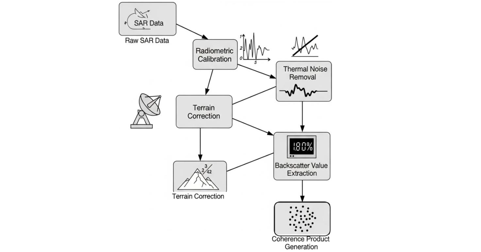
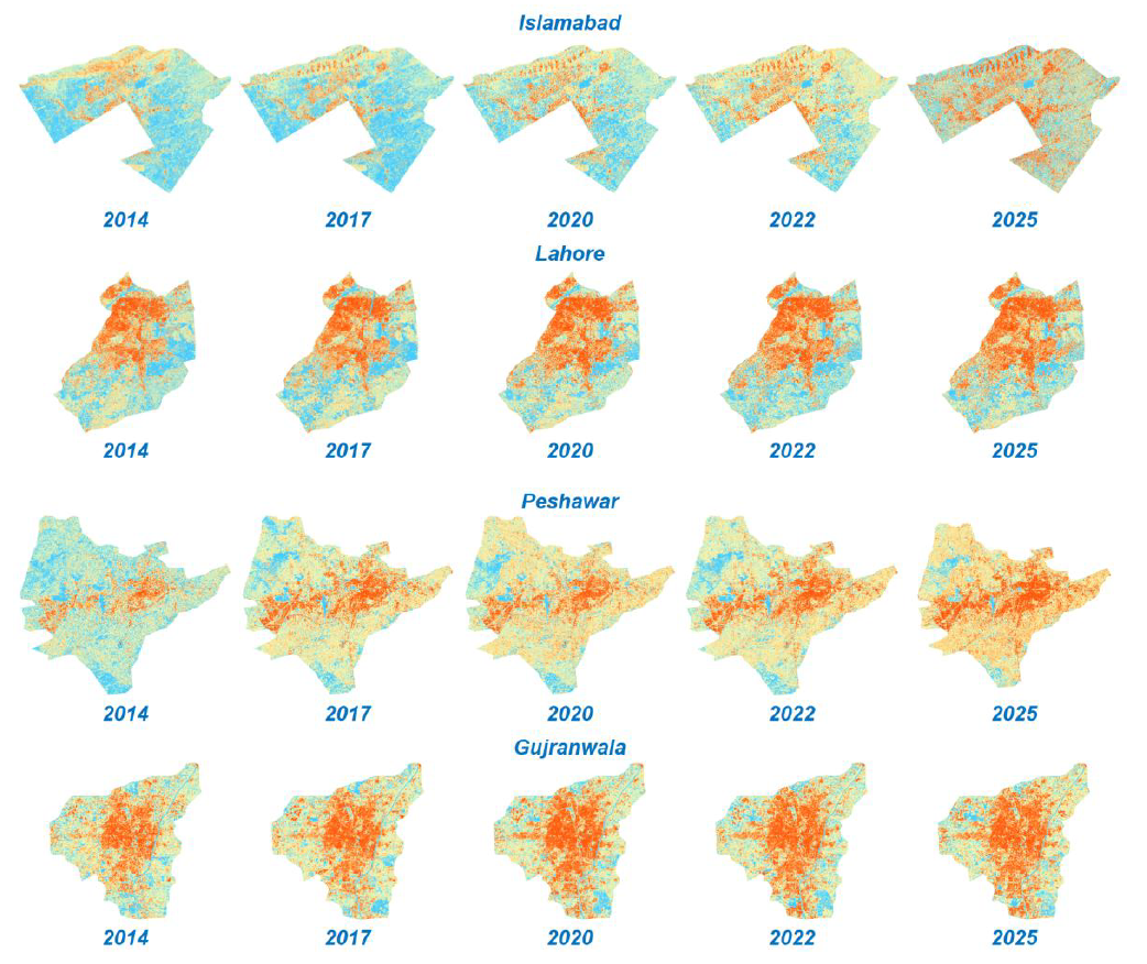
This project focuses on using advanced radar remote sensing techniques to study how rapid urban expansion alters land use and contributes to urban heat island (UHI) formation. With cities growing at unprecedented rates, conventional optical satellite imagery often faces limitations such as cloud cover, restricted revisit cycles, and dependence on daylight. Synthetic Aperture Radar (SAR) overcomes these constraints by offering consistent, high-resolution, all-weather imaging capabilities that are essential for monitoring dynamic urban landscapes. By applying polarization and coherence analyses, the system can differentiate between built-up areas, vegetation cover, and open land, thus allowing for precise mapping of sprawl patterns over time. This provides a reliable framework to assess the pace and direction of urban growth, while also generating crucial datasets for understanding the cascading effects of sprawl on microclimate and environmental balance.
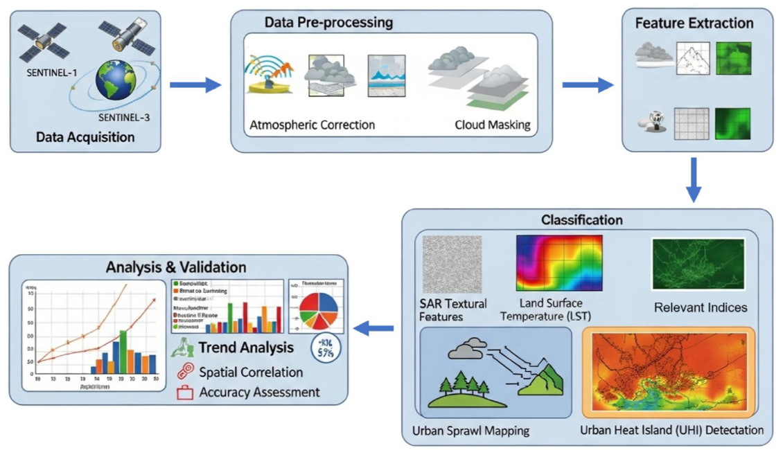
A central aspect of this project lies in connecting land-use transformations with the intensification of UHIs, a phenomenon where built-up surfaces like concrete and asphalt absorb and retain heat, leading to elevated temperatures compared to surrounding rural areas. Through temporal SAR analysis, the project identifies subtle changes in surface structure, material properties, and urban density that directly contribute to heat accumulation. By correlating SAR-derived urban metrics with temperature and thermal data from complementary sources, a comprehensive model of UHI formation and evolution is developed. This enables the detection of critical hotspots where rising temperatures pose risks to public health, increase energy demands, and exacerbate environmental stresses such as poor air quality and reduced vegetation cover. The integration of SAR’s reliable temporal monitoring with environmental modeling creates a powerful tool to capture not just the physical expansion of cities but also the invisible thermal impacts embedded within that growth.
Beyond diagnostics, this work contributes actionable intelligence for policymakers, urban planners, and environmental managers. Insights derived from SAR-based sprawl and UHI monitoring can guide zoning policies, infrastructure investments, and the implementation of green interventions such as urban forests, reflective roofing, and sustainable drainage systems. By providing decision-makers with near-real-time and longitudinal data, the system ensures that urban development strategies can prioritize resilience, climate adaptation, and equitable resource allocation. Additionally, the methodology holds potential for global application, particularly in rapidly urbanizing regions where ground-based measurements are scarce or inconsistent. In sum, the project not only advances the technical frontiers of SAR-based environmental monitoring but also delivers practical solutions to one of the most pressing challenges of the 21st century: achieving sustainable urban development while mitigating the environmental and social costs of unchecked sprawl and intensifying heat islands.
Faculty
-
Dr. Muhammad Moazam FrazDr. Muhammad Moazam Fraz
-
Dr. Zuhair ZafarDr. Zuhair Zafar
Students
-
Muhammad Ammar
-
Muhammad Dawood Rizwan
-
Usama Athar