Multi-year Wheat Mapping from Satellite Time Series Leveraging Superpixel-Based Active Learning for Data Sparse Regions
Multi-year Wheat Mapping from Satellite Time Series Leveraging Superpixel-Based Active Learning for Data Sparse Regions
Given the escalating levels of food insecurity, particularly in underdeveloped nations, automated solutions of agriculture land distribution management need to be put forward. A recent surge in the generation of high-resolution satellite data has improved the automated analysis of agriculture land distribution, providing valuable information regarding crop health monitoring, agro-meteorological disaster detection and crop production statistics to policymakers, allowing them to make more informed decisions regarding crop management and food security. However, acquisition of ground data is a challenging task in under-developed countries due to limited resources and inconsistent agricultural practices. Additionally, small-scale fields and largely heterogeneous crop distribution with frequent cloud cover pose further challenges. To address this gap, the study proposes (1) a methodology for curating initial ground data through visual interpretation in case no ground data is available, (2) a dataset for segmentation of small-holder wheat farms in South-Asian region spanning from 2020 to 2022 for 50km2 area (3) an active learning based framework for automated ground-truth data generation. This cost-effective approach harnesses the potential of superpixels to accurately generate thematic maps while simultaneously quantifying prediction uncertainties. The proposed methodology is rigorously evaluated for generalizability, encompassing multiple years and diverse geographical contexts that exhibit temporal, spatial and spectral variations. The results show an accuracy and f1 score of 87.9\% and 91.70\% for the year 2020 and 92.54\% and 95.58\% for 2021. The results demonstrate the capability of the proposed approach to generate large-scale segmentation maps for areas with small-scale fields, large cloud cover, heterogeneous crop distribution and limited to no ground truth data. Thus improving the applicability and efficiency of crop mapping efforts in under-developed countries.
(a) The location map for Pakistan, the region under study (b) the study area map for Punjab, Pakistan with the 2 study sites of Gujranwala and Sargodha highlighted in red and yellow, respectively (c) Sentinel-2 imagery for Sargodha region (d) Sentinel-2 imagery for Gujranwala region
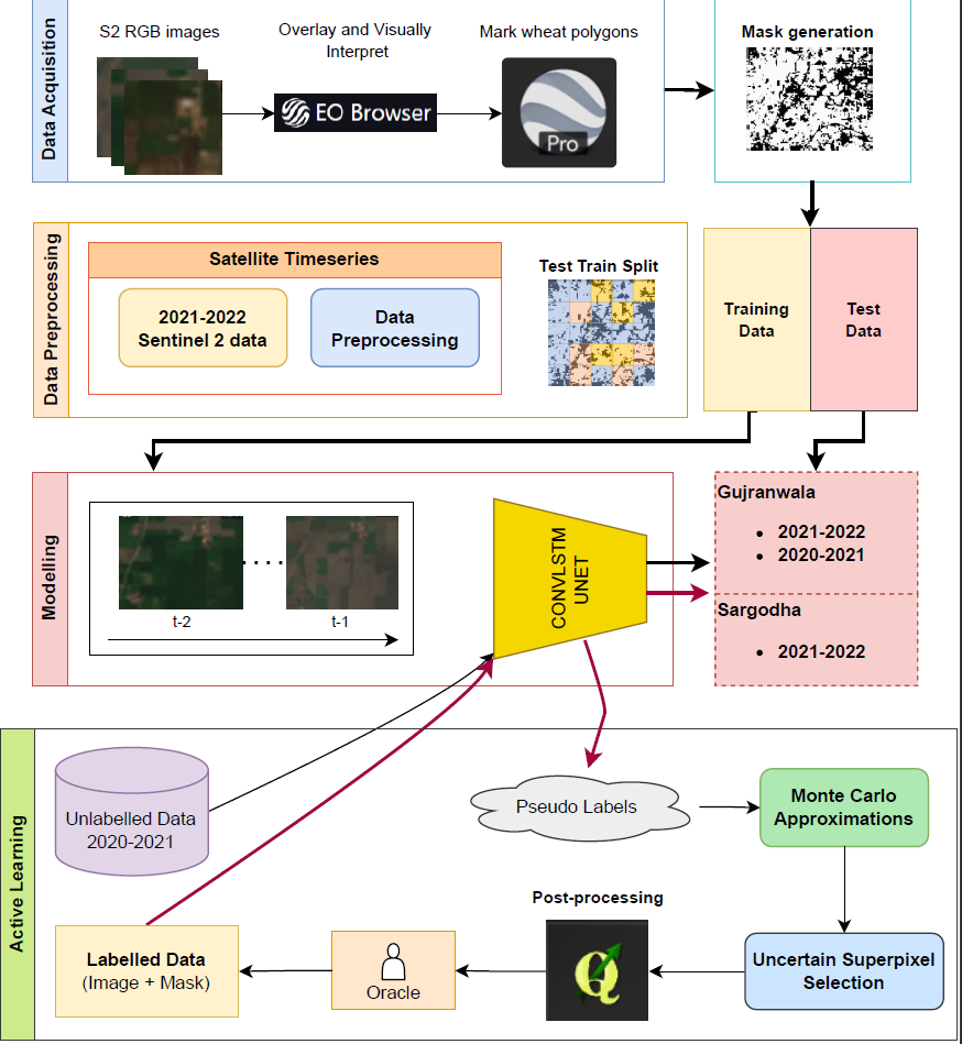
Overall framework for the study highlighting: the data acquisition procedure, data preprocessing, test/train splits, model training and testing followed by the procedure of the active learning pipeline
2. Multi-year Monitoring of Wheat Phenology and Effect of Climate Change in the South Asian Region using Sentinel-2 NDVI Time-Series Analysis. SPIE, Netherlands (2023). https://doi.org/10.1117/12.2683148