8

Uncovering Abiotic Stress in Winter Wheat Through Multi-Sensor Imagery Fusion

Uncovering Abiotic Stress in Winter Wheat Through Multi-Sensor Imagery Fusion

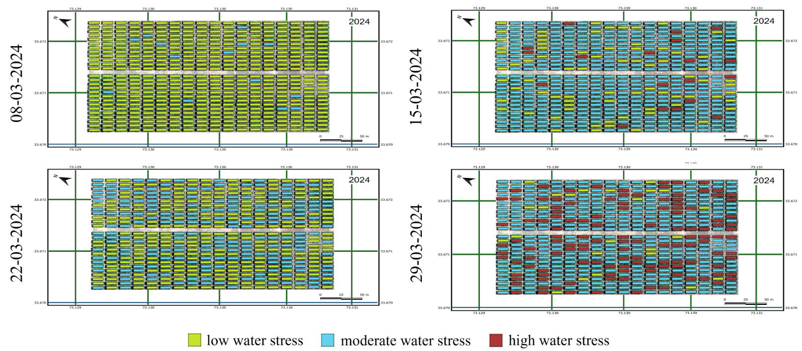
Wheat (Triticum aestivum L.) is one of the most important staple crops worldwide, playing a crucial role in ensuring global food security. A significant proportion of wheat cultivation occurs in rain-fed agricultural systems, which are highly vulnerable to water scarcity and drought stress. Drought remains one of the most critical abiotic stressors, causing substantial reductions in both yield quantity and grain quality. The increasing frequency and severity of droughts, exacerbated by climate change, pose a growing challenge to wheat production systems. Drought stress is characterized by three primary factors: intensity, timing of incidence, and duration. The variability in these factors makes it challenging for plant breeders and agronomists to determine the most effective drought adaptation strategies. The timing of the water deficit is particularly crucial, as water stress at different phenological stages affects wheat productivity differently. Early-season drought can hinder tillering and canopy development, while stress during the reproductive phase can lead to significant reductions in grain fill and final yield. Given these complexities, there is an urgent need for advanced tools and methodologies to monitor drought stress and develop predictive models for mitigating its impact on wheat production.
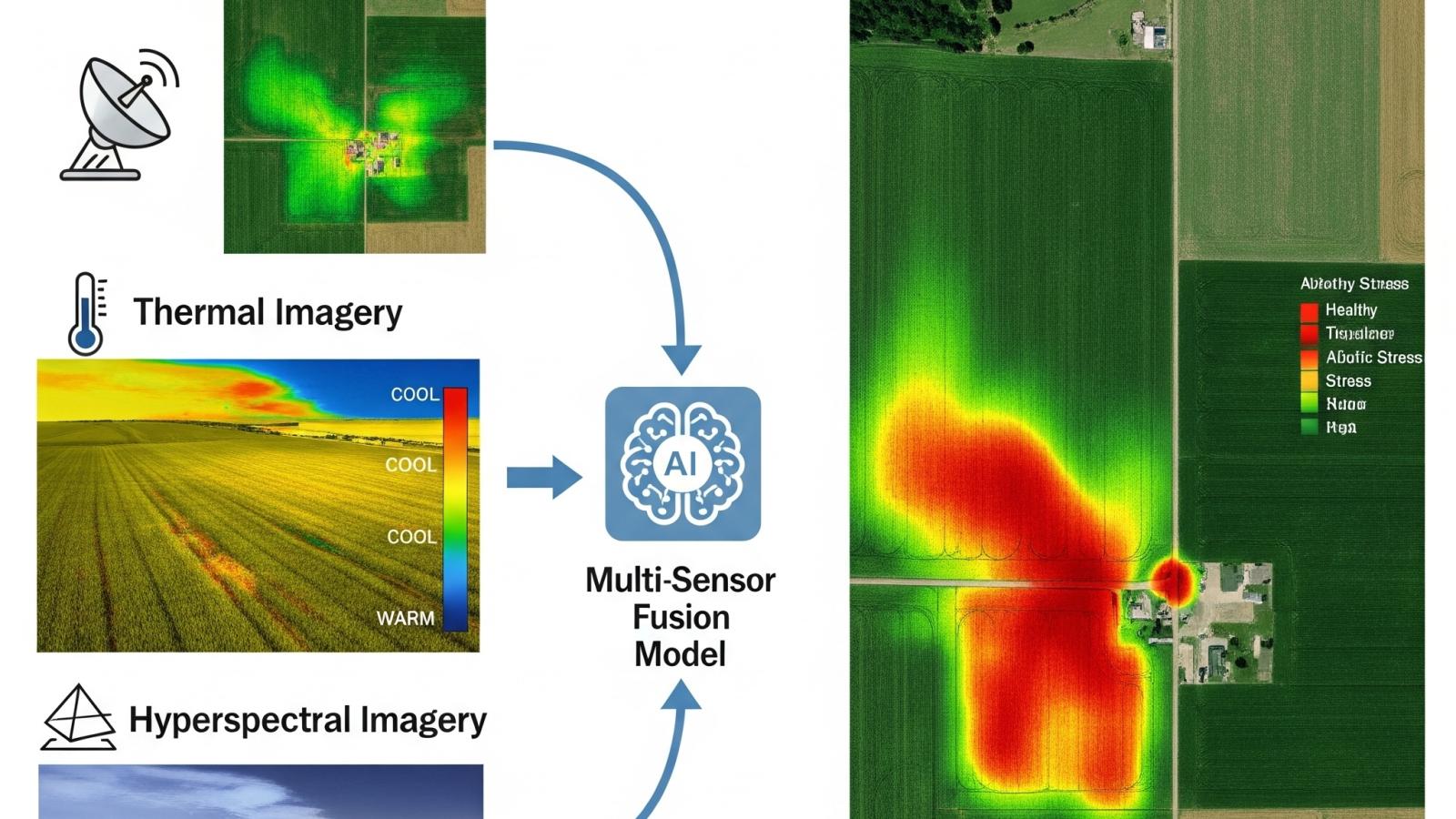
Recent research efforts have been increasingly directed toward understanding crop responses to a wide array of biotic and abiotic stresses, with a strong focus on water deficit stress. This emphasis is crucial given the anticipated worsening of global water scarcity due to climate change. Insights into drought stress tolerance, particularly regarding physiological and morphological traits, are essential for advancing drought stress monitoring, germplasm screening, and genotypic evaluation. One of the primary objectives in modern plant breeding is the development of drought-resilient wheat genotypes capable of maintaining high grain productivity under unfavorable environmental conditions. Conventional methods for monitoring crop health and estimating yield rely on ground-based surveys, visual assessments, and manual sampling. While these techniques provide valuable insights, they suffer from several limitations, including high labor costs, time constraints, and limited spatial coverage. Moreover, traditional yield prediction models often rely on meteorological data or indirect proxies, such as leaf chlorophyll content, which may not fully capture the dynamic nature of plant-water interactions. These constraints highlight the necessity for data-driven approaches that integrate real-time environmental monitoring with advanced computational models.
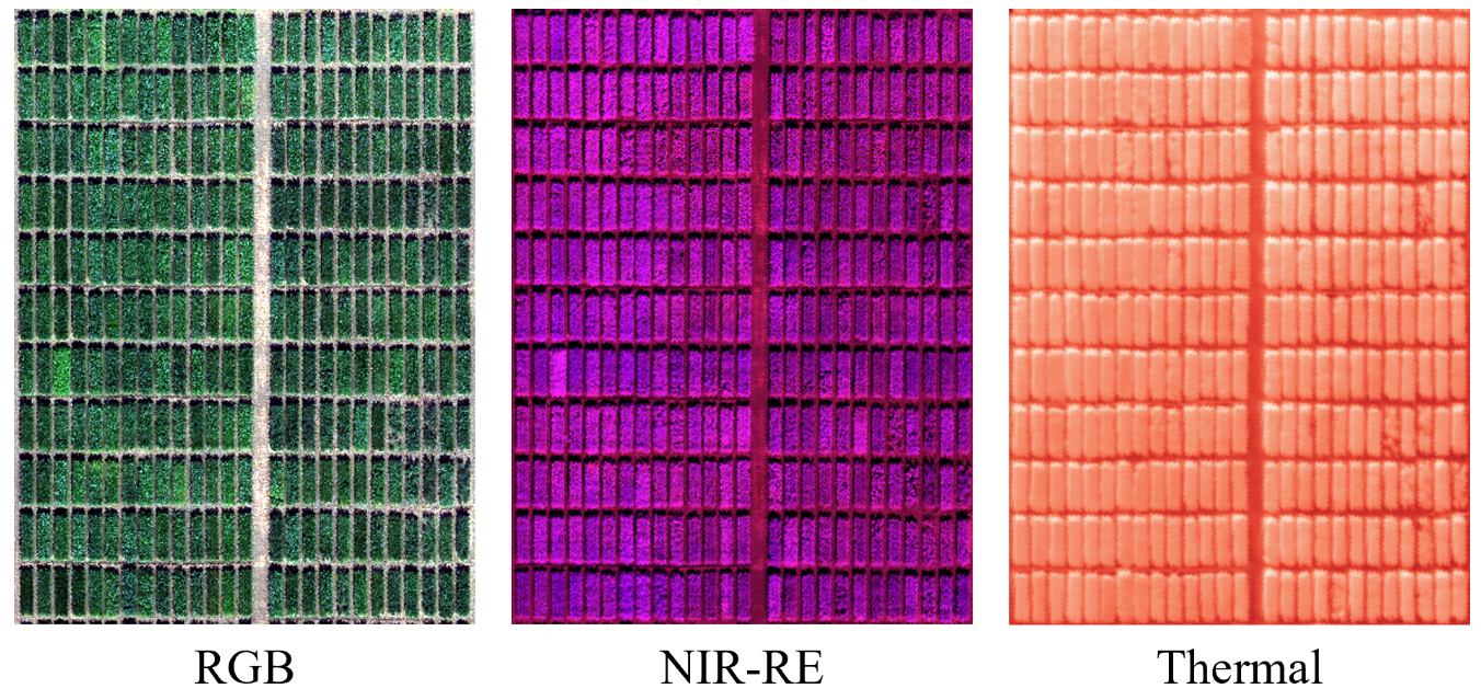
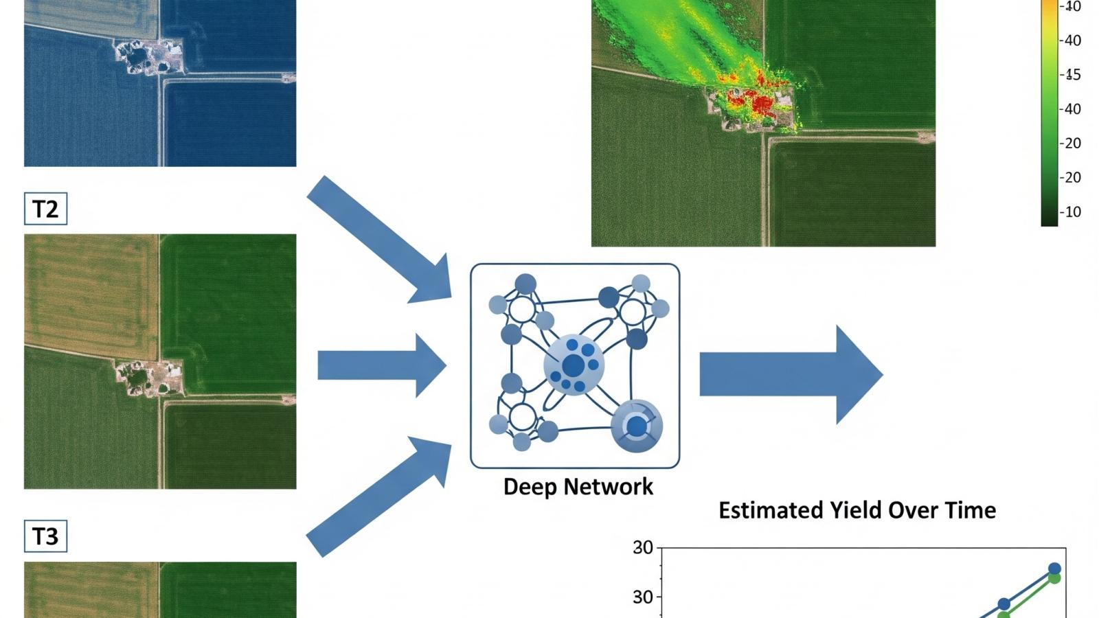
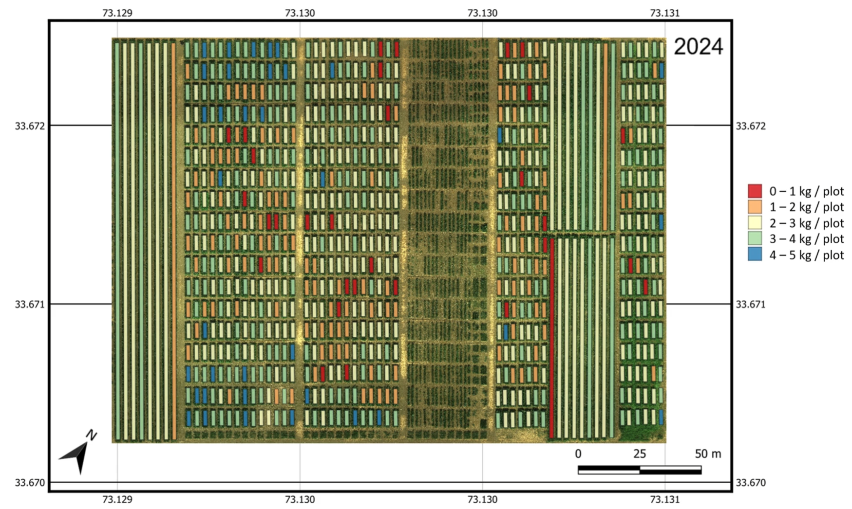
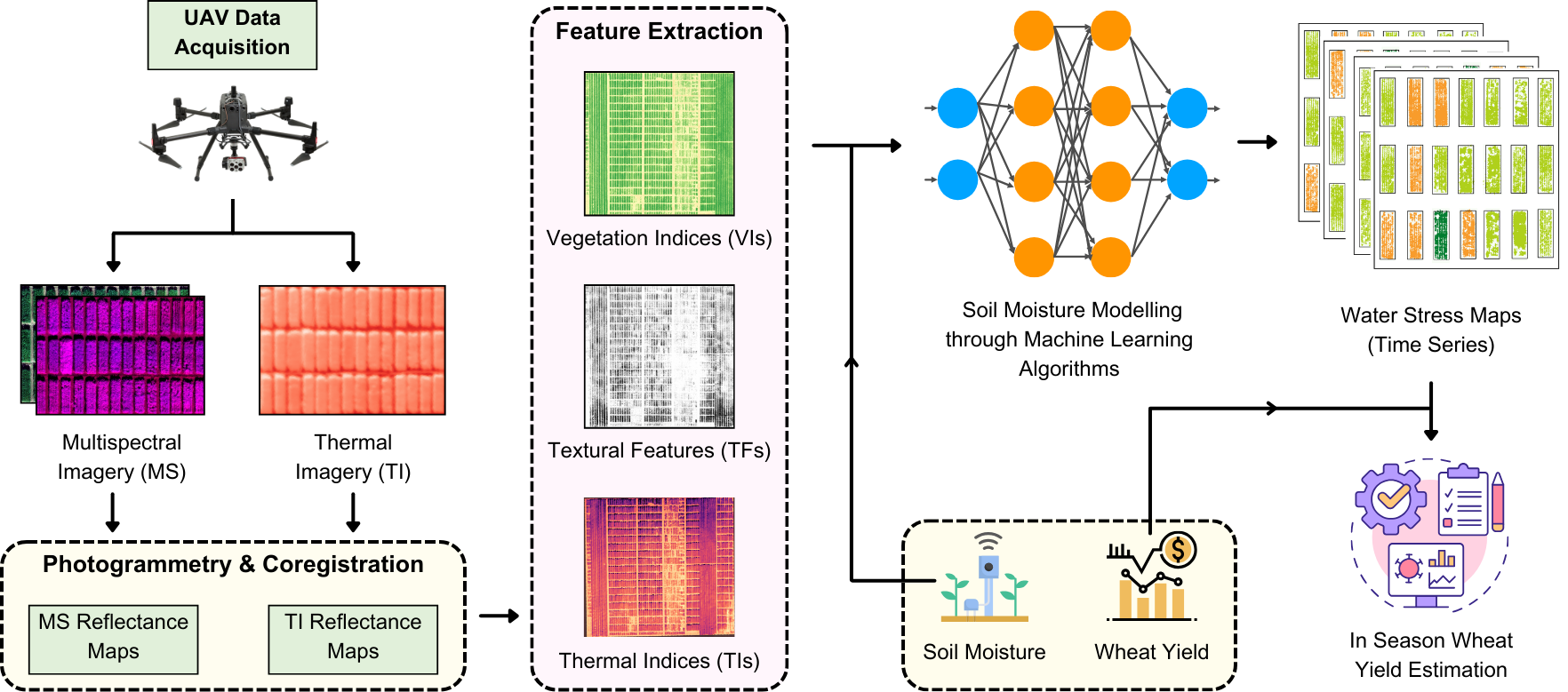
This work leverages UAV-borne multispectral and thermal imaging combined with IoT-based soil moisture data to enhance early-season yield estimation in rain fed wheat systems. Specifically, the objectives of this research are: (i) To assess the effectiveness of UAV-based spectral and thermal indices, along with textural features, in predicting early-season wheat yield, (ii) To evaluate the role of soil moisture dynamics in influencing yield outcomes at different growth stages, (iii) To develop a predictive framework that integrates multi-modal remote sensing features for improved yield forecasting, and (iv) To generate spatial distribution maps of predicted yield, enabling the identification of drought-prone areas within the field. This work contributes to the development of data-driven decision support systems for precision agriculture. The integration of UAV-based sensing with AI-driven yield forecasting models presents a novel approach for optimizing water resource management and enhancing wheat productivity under drought-prone conditions.
Faculty

Students

  • Muhammad Ali
  • Usama Athar
Gemini_Generated_Image_f71vgjf71vgjf71v

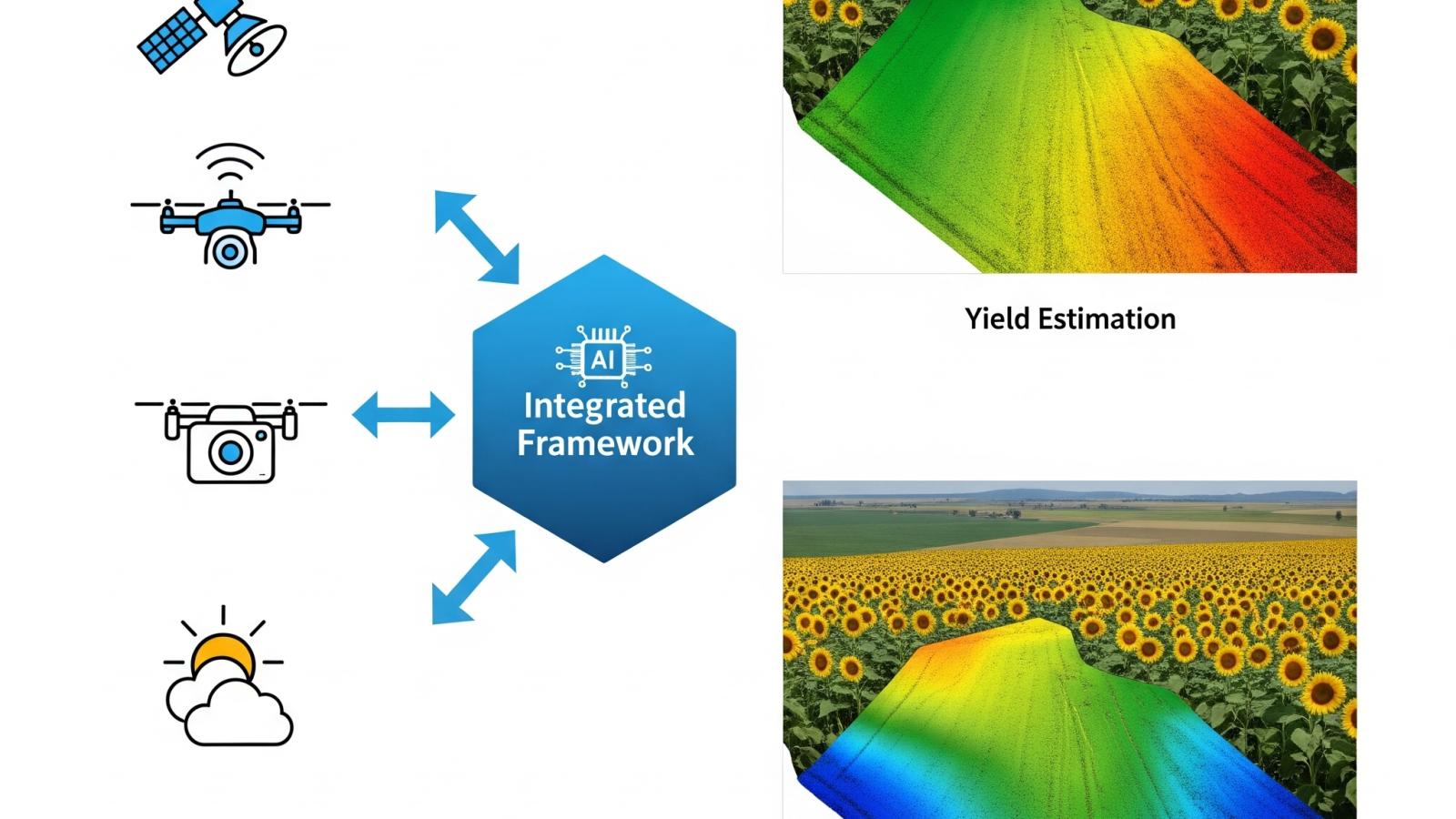
Multi-Trait, Multi-Season Framework for Accurate Sunflower Yield and Oil Content Estimation

Multi-Trait, Multi-Season Framework for Accurate Sunflower Yield and Oil Content Estimation

Achieving food security, promoting sustainable agriculture, and ensuring environmental sustainability are paramount for sustainable human development. In this context, sunflower cultivation serves as a crucial source of edible oil, while offering opportunities for economic development and habitat diversification. However, it is characterized by genetic variability, influencing oil content and seed yield in different varieties and genotypes. This poses numerous challenges in developing generalized estimation methods applicable across all sunflower types due to varying impact of climate and cultivation practices. Obtaining accurate estimations becomes crucial, considering the differences within varieties and influence of other factors like seed size and maturity. Traditional methods of Soxhlet extraction are time-consuming, prompting the exploration of advanced techniques like near-infrared spectroscopy (NIRS) and nuclear magnetic resonance (NMR), albeit with associated challenges of cost and expertise.

mtms0

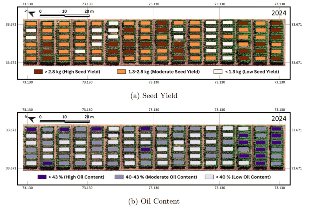
Precise estimation of seed yield and oil content holds immense importance for both farmers and breeders while selecting high-yielding sunflower varieties. With the advent of precision agriculture techniques through remote sensing, integration of cutting-edge technologies, particularly Unmanned Aerial Vehicles (UAVs) equipped with artificially intelligent capabilities and multispectral sensors, is a promising way forward. UAV data, captured beyond the visible spectrum, facilitates crop health assessment, aiding in identifying stress, diseases, or nutrient deficiencies. This assists in determining optimal harvest times by monitoring crop development over the season and identifying peak oil content stages. To analyze the morphological and physiological crop traits that impact sunflower yield, understanding their intricate relationships is imperative. Taller plants with larger canopies generally exhibit higher oil content, but excessively tall plants may allocate more energy to stem development. Similarly, canopy characteristics, area and density, impact photosynthetic efficiency and, consequently, seed development in the later stages of a crop’s season. The interplay of these factors is complex, influenced by genetic traits, environmental conditions, and agricultural practices. There has been limited research on the effects of morphological and physiological traits on sunflower seed yield and oil content, whereas elementary yield prediction methodologies either rely on satellite imagery with coarse results or deal with other oilseed crops.

mtms1

Recent years have seen a growing interest in non-destructive and scalable techniques for estimating seed yield and oil content in oilseed crops. Traditional laboratory methods including gravimetric analysis and solvent-based techniques, while accurate, are time-consuming and environmentally hazardous. NIRS, Fourier-Transform Infrared Spectroscopy (FTIR), and NMR have also been explored because of their efficiency and minimal sample preparation requirements, but their cost, sensitivity to moisture and composition, and calibration complexity have limited field-scale deployment. Remote sensing has emerged as a viable alternative, providing rapid, non-invasive estimation of crop traits over time. Satellite-based approaches have demonstrated promising results in oilseed yield forecasting, but they are often constrained by coarse spatial resolution and limited revisit frequencies, making them suboptimal for field-scale phenotyping. In contrast, UAV-based imaging enables high spatial and temporal granularity, well-suited for plot-level monitoring of morphological and physiological dynamics throughout the growing season.

mtms2

Machine learning models have been increasingly applied to spectral and structural data for yield prediction in sunflower and related crops. However, most of these studies rely on single vegetation indices (NDVI or EVI), limiting their ability to fully capture the complexity of plant structure and its physiological status. Moreover, most existing approaches overlook critical features like fresh weight, dry weight, moisture content, and floral attributes like head count and flower coverage area, all of which provide complementary signals related to crop productivity.

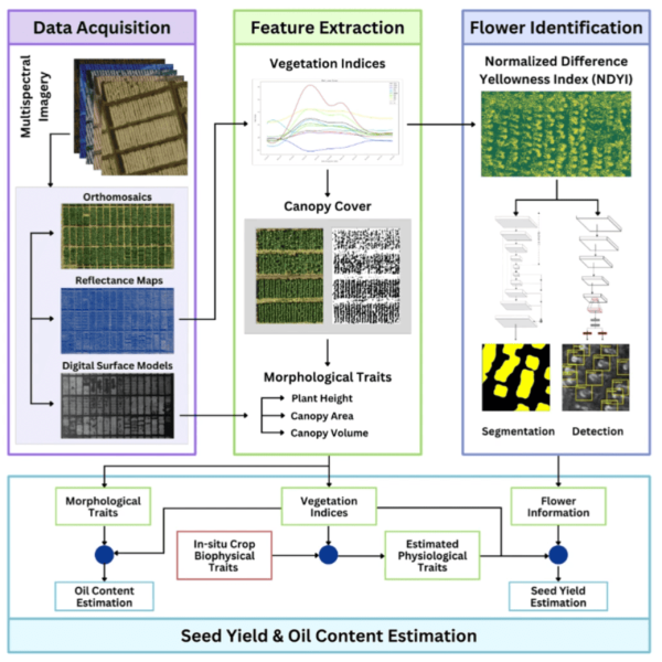
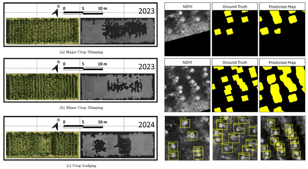
Addressing these limitations, this work explores the integration of UAV-derived vegetation indices, structural traits, physiological features, and floral attributes to improve the estimation of sunflower seed yield and oil content across multiple seasons. The objective is to address key challenges in high-throughput phenotyping by using these parameters to develop estimation models for sunflower breeding programs. This approach is intended to support crop breeders in efficiently screening and selecting superior sunflower varieties, with potential benefits for oilseed production systems in regions where edible oil dependency is a major concern. The methodological framework incorporates 12 vegetation indices, physiological features (fresh weight, dry weight, moisture factor), and morphological traits (plant height, canopy area, canopy volume) to provide a comprehensive representation of growth progression over the season. Machine learning models are trained on remotely sensed time series data to investigate the relationships between crop traits and yield potential. This approach addresses limitations of previous studies that have predominantly relied on RGB imagery or isolated vegetation indices. In addition, deep learning-based techniques are employed on multispectral imagery to extract floral attributes. Semantic segmentation and object detection models are applied to Normalized Difference Yellowness Index (NDYI) reflectance maps for estimating flower coverage area and head count, respectively. These features are incorporated into the modeling pipeline to explore their relevance for pre-harvest crop trait prediction.

mtms3

This work makes the following key contributions: (i) Extracting key morphological & physiological traits from UAV multispectral data to estimate sunflower seed yield and oil content across multiple seasons, (ii) Mapping sunflower head count and flower coverage area through relevant object detection and semantic segmentation methods on Normalized Difference Yellowness Index, and (iii) Comparison and analysis of 12 different vegetation indices, both independently and when used with aggregated feature sets, to identify the best feature combinations for estimating seed yield and oil content. Based on the limitations of existing approaches, this work investigates the added value of combining multiple attributes derived from remotely sensed data. The study specifically investigates whether the integration of structural, physiological, and floral attributes leads to improved estimation accuracy for sunflower seed yield and oil content compared to VI-based methods.

mtms4

Video

Faculty

Students

  • Usama Athar
  • Muhammad Ali

Publications

  • Athar, U., Ali, M., Zafar, Z., Khurshid, H., Berns, K. and Fraz, M.M., 2024, December. Merging UAV-Derived Metrics with Crop Physiology to Estimate Sunflower Yield. In 2024 International Conference on Frontiers of Information Technology (FIT) (pp. 1-6). IEEE. https://doi.org/10.1109/FIT63703.2024.10838400
  • Ali, M., Athar, U., Zafar, Z., Khattak, H.A., Berns, K. and Fraz, M.M., 2025, August. Combining UAV Multispectral Data & Crop Morphological Features for Sunflower Oil Content Estimation. In IGARSS 2025-2025 IEEE International Geoscience and Remote Sensing Symposium (pp. 2973-2977). IEEE. https://doi.org/10.1109/IGARSS55030.2025.11243000
7

Phenology-Aware In-Season Yield Estimation Through Multispectral Imagery & Deep Networks

Phenology-Aware In-Season Yield Estimation Through Multispectral Imagery & Deep Networks

Agricultural productivity is fundamental for global food security amid population growth and climate variability. With an ever-rising demand for sustainable farming, efficient crop monitoring solutions increasingly rely on data-centric approaches and growth simulation techniques. Understanding crop phenology is key to agronomic planning and yield optimization. It involves studying the growth stages of crops and how they interact with environmental conditions. It significantly influences decisions related to irrigation, fertilization, pest control, disease control, and harvesting. Accurate large-scale phenological estimation facilitates optimal resource use, cost reduction, and inter-variety performance analysis. However, traditional approaches such as manual field observations are highly time-consuming. Moreover, they are prone to error and spatial limitations, highlighting the need for scalable and precise phenological monitoring.

Phenology is a fundamental factor influencing yield formation, crop health, and stress response mechanisms. Crop health is closely tied to phenology because different growth stages exhibit varying levels of vulnerability to biotic and abiotic stressors. Flowering and grain-filling stages are particularly susceptible to drought and disease pressure. The ability to precisely track phenological transitions enables agronomists to make decisions that directly impact productivity in high-throughput phenotyping programs. The timing and duration of phenological stages affect the efficiency of critical agronomic interventions, including but not limited to irrigation, fertilization, pest & disease management, and harvest planning. Different growth stages have varying water requirements. Accurate phenology estimation ensures that irrigation is applied at the right time, preventing water stress or overuse. Nutrient demand fluctuates throughout the growing season. A phenology-aware fertilization strategy enhances nutrient uptake efficiency, reducing excess fertilizer application and its environmental impact. Certain phenological stages are more susceptible to pests, diseases, and abiotic stressors. Early detection enables timely preventive measures. Furthermore, harvest timing is critical for maximizing yield quality and minimizing losses. An understanding of phenology ensures optimal scheduling. Given the importance of phenology in yield formation, the ability to estimate these stages non-destructively, accurately, and at scale is highly valuable in agricultural monitoring.

Accurate crop yield prediction is one of the most sought-after goals in agricultural research and farming. Traditional yield estimation methods primarily rely on two things: (1) statistical models that do not adapt well to current climatic variations and (2) final-stage yield assessments, which only provide relevant information after harvest. In-season yield estimation, however, enables dynamic decision-making, allowing farmers and policymakers to predict and optimize yield outcomes before harvest. Estimating yield at various growth stages helps identify crop stress early and also supports better resource use and supply chain planning. Detecting yield-affecting stress factors (drought, nutrient deficiencies, pest infestations) in real-time enables timely interventions. Farmers can adjust fertilizer, pesticide, and irrigation applications based on yield forecasts, reducing waste and costs. Governments, exporters, and agribusinesses can forecast grain production, helping in trade and storage decisions. To improve in-season yield estimation, it is critical to incorporate phenological information, as different stages contribute differently to final grain formation. By integrating phenology-aware features into yield models, more robust, generalizable, and high-precision predictions are made possible.

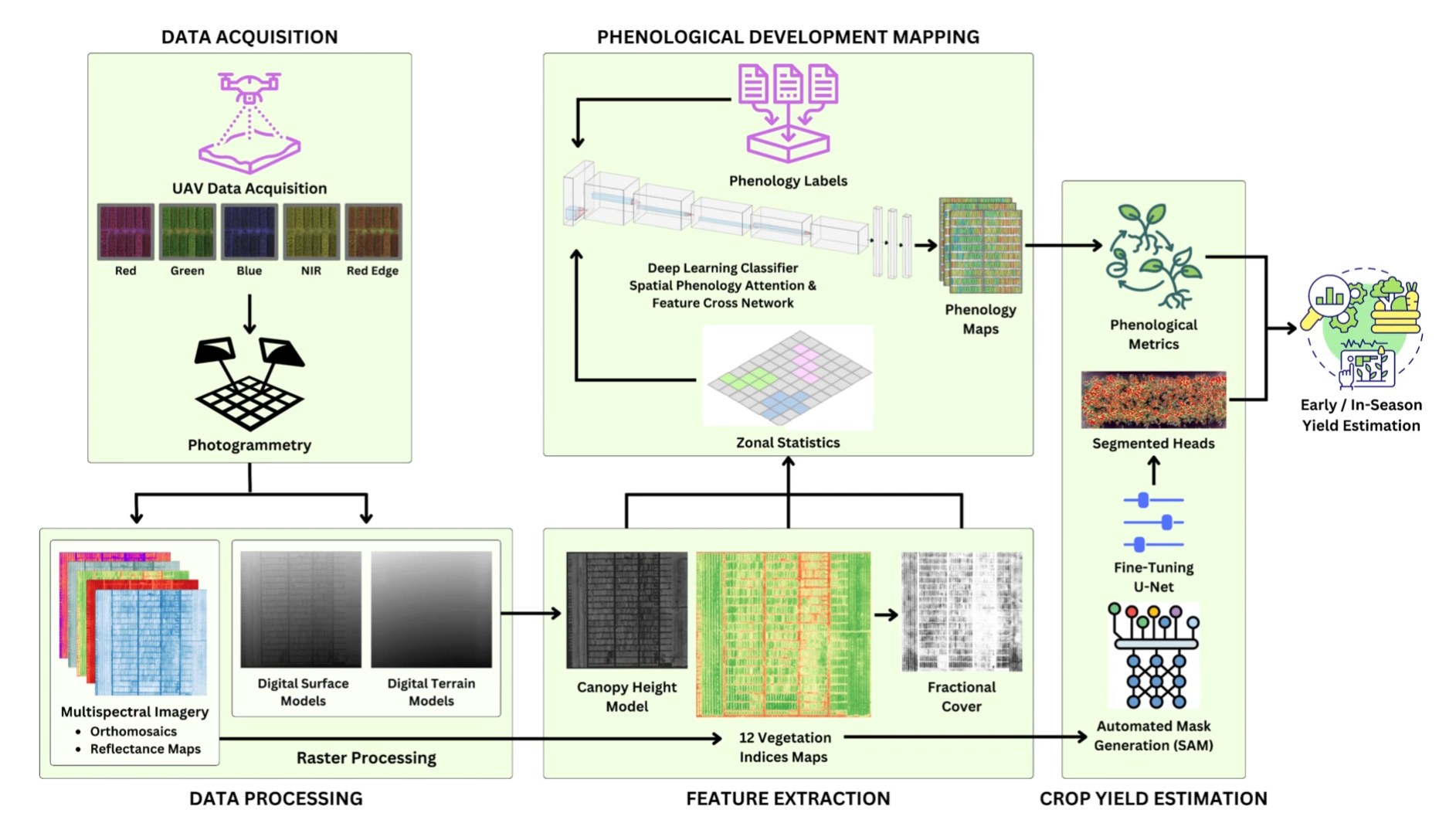
Traditional phenology assessment and yield forecasting methods face scalability challenges. They also lack spatial consistency across large landscapes. Satellite imagery provides broad coverage but lacks the spatio-temporal resolution for fine-scale phenological variations. Conventional models rely on historical yield records and limited vegetation indices. These models overlook real-time crop progression and show poor adaptability to unseen regions and varying climatic scenarios. Existing yield estimation methods often treat crop development as static, ignoring phenological transitions, which are critical to yield formation. UAV-based phenology-driven yield estimation remains underexplored, with most work focusing on spectral indices while neglecting structural traits. To address these gaps, this paper proposes a phenology-aware, in-season yield estimation framework using UAV multispectral imagery and deep neural models. The proposed approach automates phenological mapping, improves in-season yield forecasting, and segments wheat heads for more reliable grain count estimation.

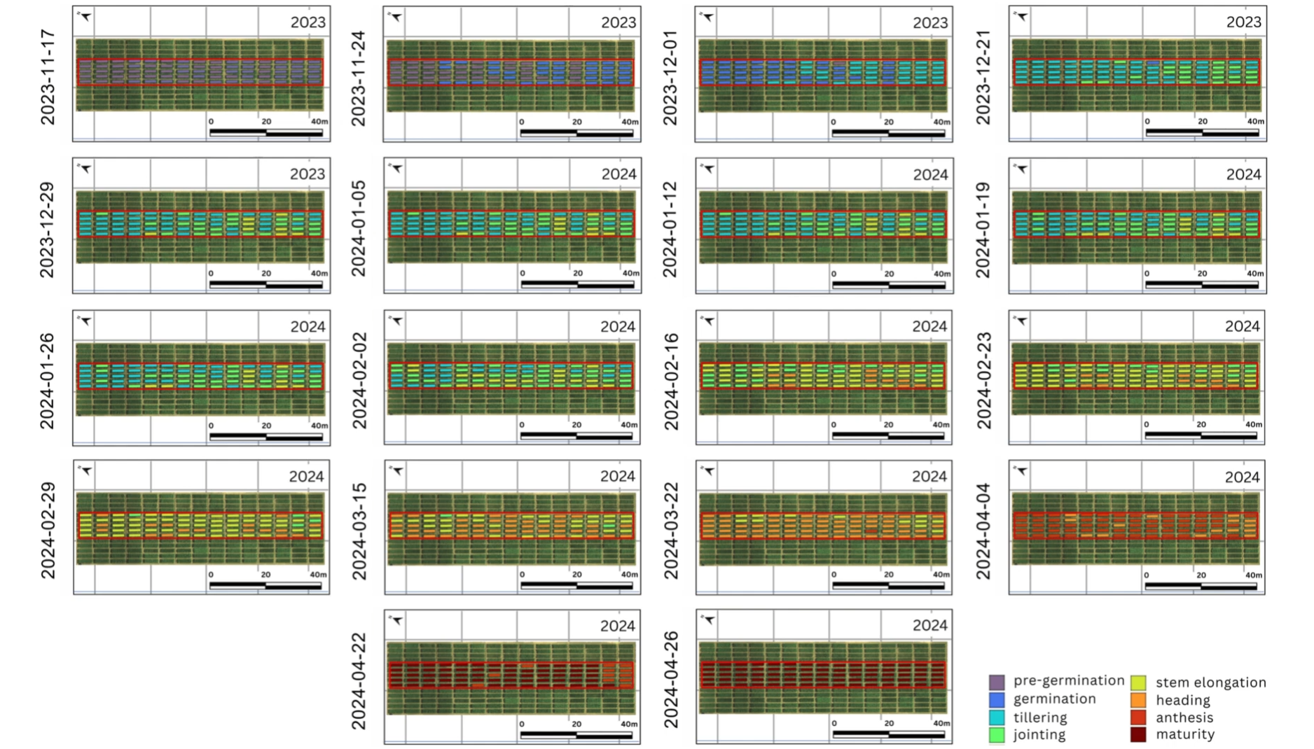
The main contributions of this work are: (i) Developing a novel deep network, SPARC (Spatial Phenology Attention and Feature Cross), which captures spatial and cross-feature dependencies to estimate phenological stages from UAV-derived vegetation indices and structural features, (ii) Implementing semi-automated wheat head segmentation using SAM 2-generated masks and a fine-tuned U-Net model for accurate estimation of head coverage and density across plots, (iii) Extracting both phenological and morphological features at the plot level and demonstrating their combined utility in improving in-season yield estimation over conventional spectral-based approaches, and (iv) Validating the proposed pipeline using data collected over 18 timestamps throughout a full wheat growing season. These contributions demonstrate how the combination of phenological and morphological traits can enable scalable and accurate in-season yield estimation.

Video

Faculty

Students

  • Usama Athar
  • Muhammad Ali

Publications

  1. Athar, U., Ali, M., Zafar, Z., Mahmood, Z., Berns, K., Bourennani, F. and Fraz, M.M., 2026. Phenology-aware in-season crop yield estimation through UAV multispectral imagery and deep neural networks. Computers and Electronics in Agriculture240, p.111210. https://doi.org/10.1016/j.compag.2025.111210
6

Multi-Plant Leaf Disease Detection & Segmentation

Multi-Plant Leaf Disease Detection & Segmentation

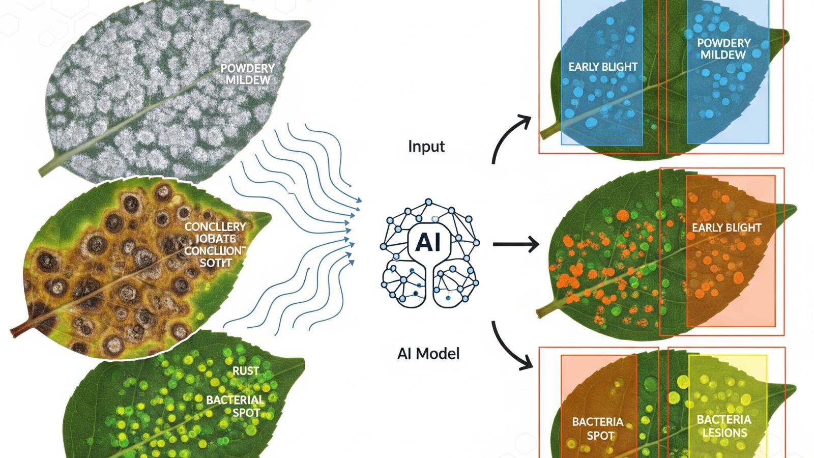
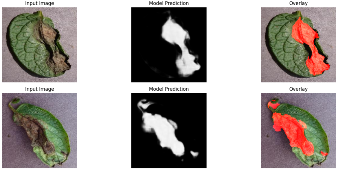
This project comprises a comprehensive AI workflow built to detect and segment a diverse array of leaf diseases across multiple plant species. It tackles two critical tasks: first, classifying up to 67 different disease categories using a DenseNet-201 architecture; second, pinpointing disease regions via semantic segmentation using a DeepLabV3+ model with ResNet-101 backbone. By combining both classification and segmentation in a unified pipeline, the system dramatically enhances disease identification precision and interpretability, providing detailed localization, not just a disease label.

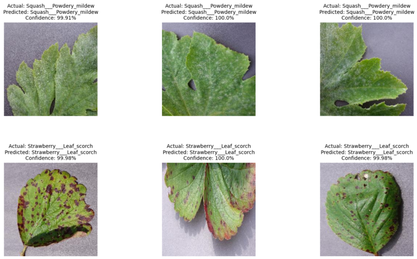
The pipeline starts by ingesting curated leaf images from multiple Kaggle sources, organized into training, validation, and test sets. For disease detection, the project implements DenseNet-201 with robust data augmentation and custom training callbacks, achieving an impressive 97.03% classification accuracy across 67 disease classes. Simultaneously, the segmentation module leverages DeepLabV3+ enhanced with Atrous Spatial Pyramid Pooling (ASPP) and ResNet-101, trained on annotated leaf masks. Results include clear overlay visualization of disease areas, making it easier for researchers and practitioners to assess not just the presence of disease but its precise location and extent.

This project is valuable for both research and agricultural deployment. Its modular architecture is data-driven and extensible. New disease classes or plant types can be supported by retraining or fine-tuning on additional datasets. The inclusion of both classification and segmentation makes it a powerful tool for field diagnostics and precision agriculture, enabling early detection, severity assessment, and targeted treatment guidance. Moreover, the use of notebooks and clear documentation makes the pipeline accessible and reproducible—researchers, agronomists, or developers can easily explore, adapt, and build on this foundation.

Faculty

Students

  • Isra Mansoor
  • Muhammad Abdullah
  • Usama Athar
5

Bridging UAV Precision & Satellite Scope for Largescale Phenology Estimations

Bridging UAV Precision & Satellite Scope for Largescale Phenology Estimations

Agriculture forms the backbone of Pakistan’s economy, with wheat being the most extensively cultivated crop, occupying over 9 million hectares of land and providing more than 72% of the daily caloric intake for the majority of the population. Despite its significance, wheat production in Pakistan faces numerous challenges, resulting in yields that remain below their potential. In the 2022-2023 crop year, Pakistan had an average wheat yield of 3.12 tonnes per hectare, that was below the global average at 3.55 tonnes per hectare. This underperformance underscores the urgent need for innovative solutions to optimize agricultural practices and enhance food security.

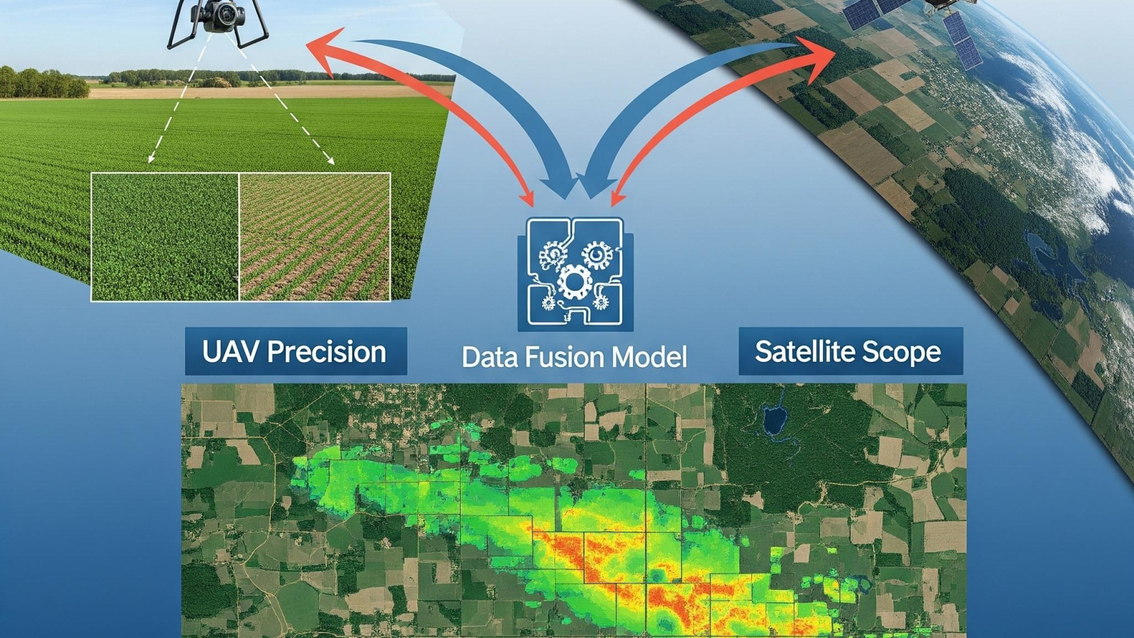
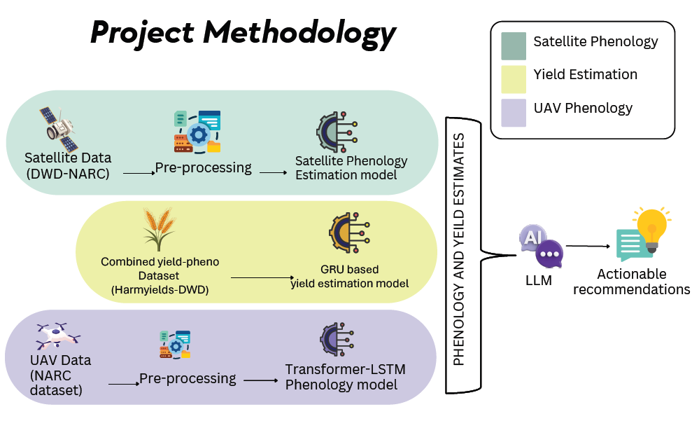
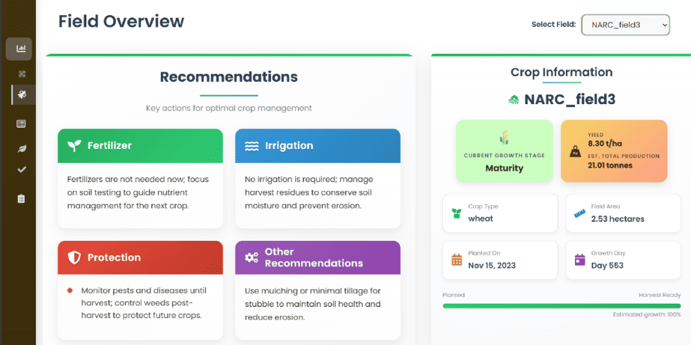
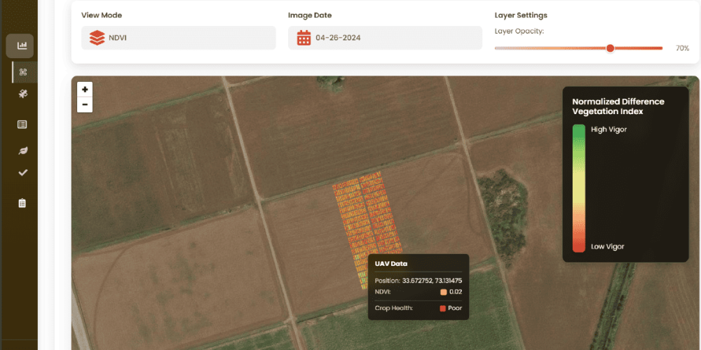
WheatInsight addresses these challenges by developing a comprehensive phenology and yield estimation system for spring wheat that leverages cutting-edge technologies in remote sensing and artificial intelligence. Wheat crops require special care and certain actions under each phenological stage. WheatInsight provides these actionable recommendations for your crop at each particular stage. The system offers two separate specialized pipelines: one utilizing high-resolution UAV imagery for field-level precision, and another employing broad-coverage satellite data for more large-scale monitoring. This approach enables WheatInsight to serve the diverse needs of both stakeholders who need precise insights, and stakeholders that prefer inexpensive and more broad insights into their crop’s phenology.

bup1

The system employs advanced deep learning techniques, including vision transformers and LSTM networks, to process temporal and spatial data for accurate phenology stage classification. For field-level analysis, our UAV-based module achieves over 90% accuracy in classifying wheat growth stages, generating detailed overlay maps that visualize phenological progression across fields. Complementing this, our satellite-based module processes multi-spectral Sentinel-2 data to provide district-wide monitoring capabilities, currently achieving close to 90% accuracy with ongoing improvements.

WheatInsight’s modular, object-oriented architecture ensures scalability and maintainability, while the Agile development methodology accommodates evolving requirements throughout the project lifecycle. The system features a user-friendly web interface with interactive visualizations such as an interactive heat map for field phenology for both UAV and satellite views, as well as a recommendation section to present users interpretations and suggestions based on the data. By delivering in-season and accurate phenology estimation and yield prediction for spring wheat and giving actionable recommendations based on it, WheatInsight aims to introduce smart agriculture practices for spring wheat in Pakistan. The system not only supports individual farmers in optimizing resource utilization and managing yield but also contributes to broader agricultural planning and food security initiatives. WheatInsight is a step towards the application of modern and sustainable agricultural practices in Pakistan, contributing directly to the UN SDGs 2,12 and 13.

bup2
bup4

Faculty

Students

  • Faizyab Ali Shah
  • Manahil Ahmad
  • Muhammad Shayan Khan Niazi
4

Advancing UAV-Based Spatio-Temporal Image Registration For Crop Breeding Programs

Advancing UAV-Based Spatio-Temporal Image Registration For Crop Breeding Programs

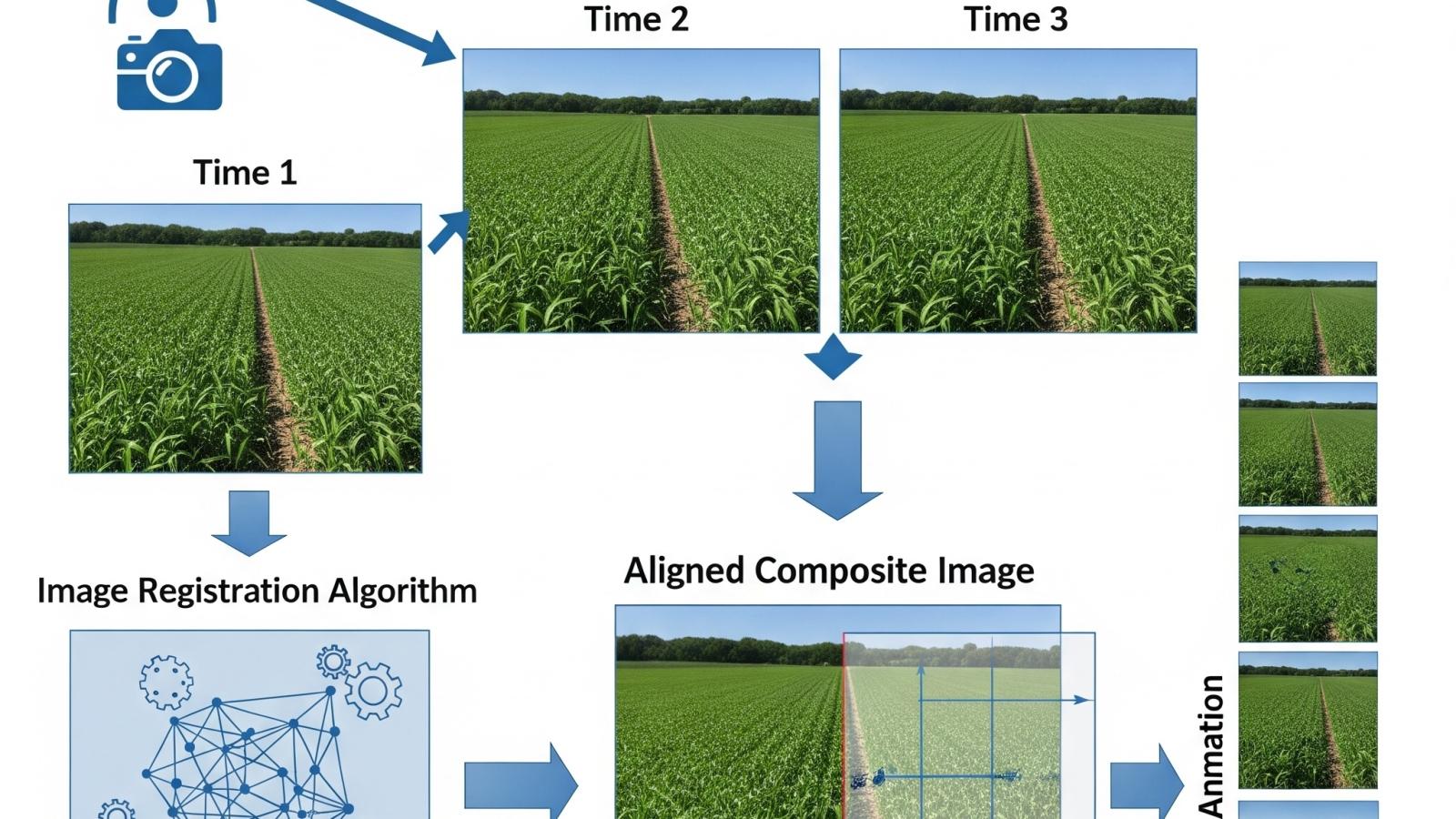
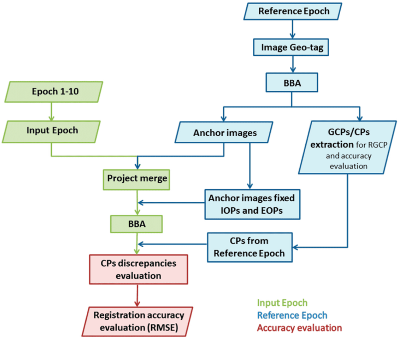
This project is designed to address one of the most critical challenges in agricultural research: the accurate alignment and analysis of large volumes of aerial imagery collected over time from Unmanned Aerial Vehicles (UAVs). Crop breeding programs depend heavily on precise phenotypic measurements across different stages of plant growth, yet variations in flight paths, illumination conditions, and field heterogeneity often make consistent temporal comparisons extremely difficult. This project focuses on developing a robust image registration framework that leverages the inherent geometric structure of agricultural fields, such as planting rows, block designs, and experimental plot boundaries, to anchor UAV imagery across multiple time points. By aligning data not just spatially but also temporally, the framework allows researchers to track subtle growth patterns, phenotypic variations, and treatment effects with high fidelity, ultimately enabling more informed selection decisions and advancing modern breeding pipelines.

ircb2

We integrate spatio-temporal modeling with computer vision techniques to ensure that each pixel and feature across sequential UAV flights can be accurately mapped to its corresponding field location and crop instance. Unlike traditional image registration methods that often struggle in open agricultural landscapes due to the repetitive textures of crops, this system introduces field-specific geometric features—such as row orientations, intersection points, and experimental layout markers, as stable anchors for registration. These structural cues enable the system to correct for positional drift, scale differences, and perspective distortions while maintaining consistency across varying growth stages where plant size, canopy density, and spectral signatures change significantly. Additionally, by combining temporal consistency checks with geometric anchoring, the system enhances robustness against environmental noise, shadow variations, and UAV positional inaccuracies. This allows the generation of time-series datasets that are spatially coherent and phenotypically reliable, paving the way for high-throughput phenotyping at an unprecedented scale.

The broader impact of this project lies in its potential to revolutionize crop breeding workflows by making UAV-based phenotyping not only faster but also more accurate and scalable. With properly registered spatio-temporal imagery, breeders can move beyond manual scoring methods and harness computational tools to quantify traits such as canopy cover, growth rate, flowering dynamics, and stress responses with unparalleled precision. Moreover, the framework opens doors to integrating multimodal UAV data, including RGB, multispectral, thermal, and hyperspectral imagery, into a unified temporal space, enabling holistic insights into plant health and productivity. By reducing data misalignment errors and ensuring temporal continuity, the system provides breeders with a reliable digital twin of field experiments, facilitating better decision-making and accelerating genetic gains. In the long run, this advancement will not only strengthen crop breeding programs but also contribute to global food security by supporting the development of climate-resilient, high-yielding crop varieties that can thrive under diverse and challenging agricultural conditions.

Faculty

Students

  • Muhammad Salman Akhtar
2

Domain Generalization in Satellite-Based Crop Mapping

Domain Generalization in Satellite-Based Crop Mapping

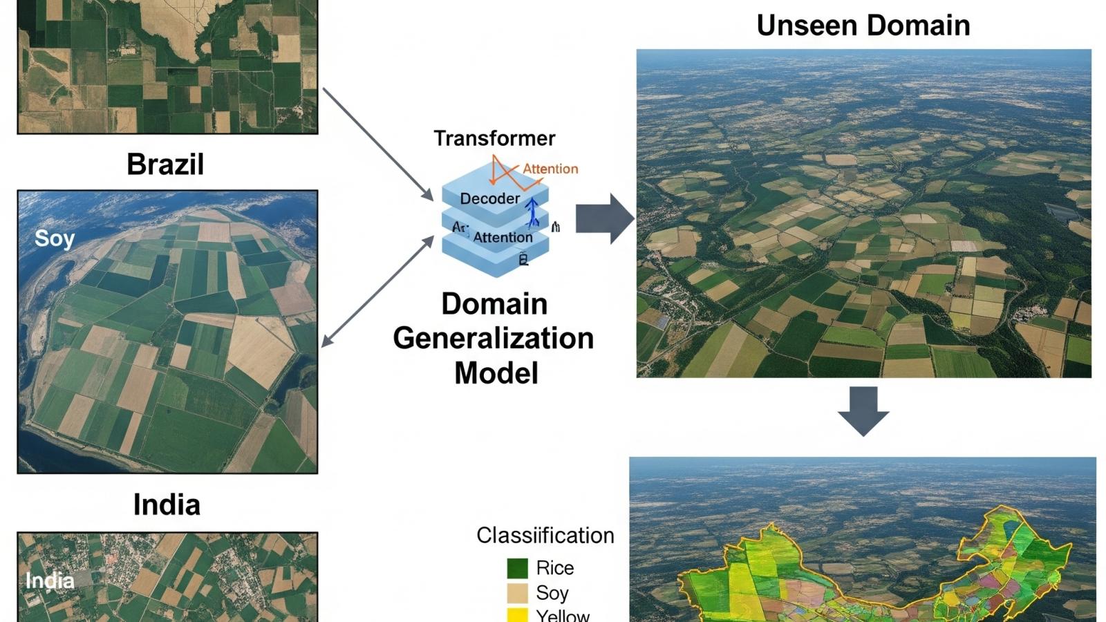
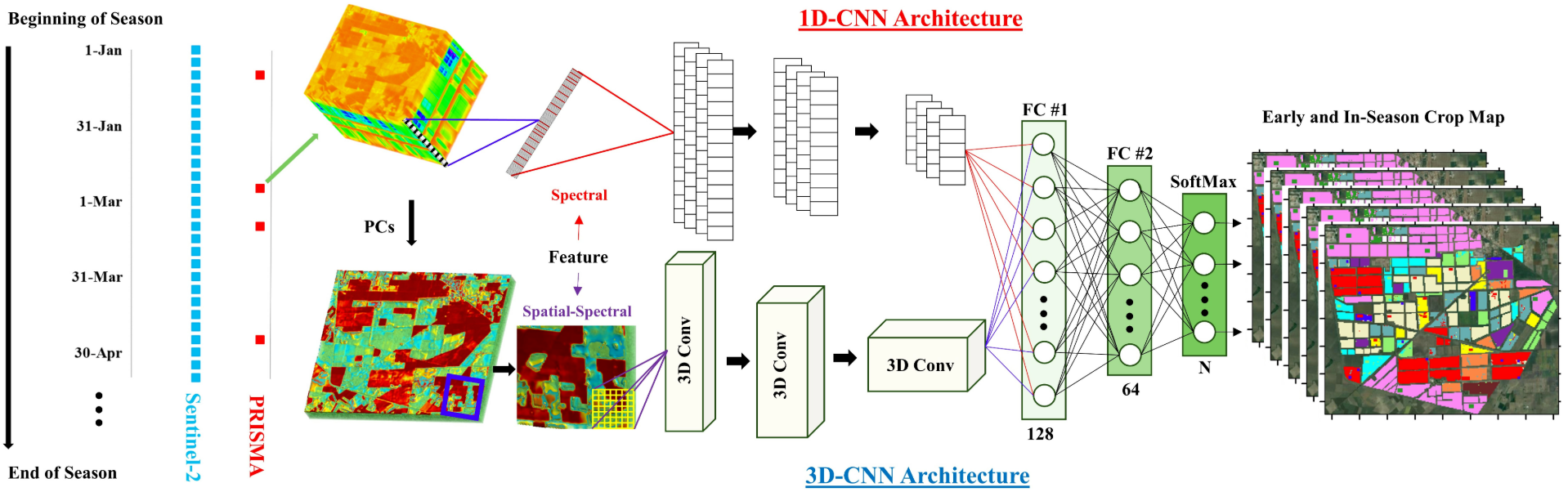
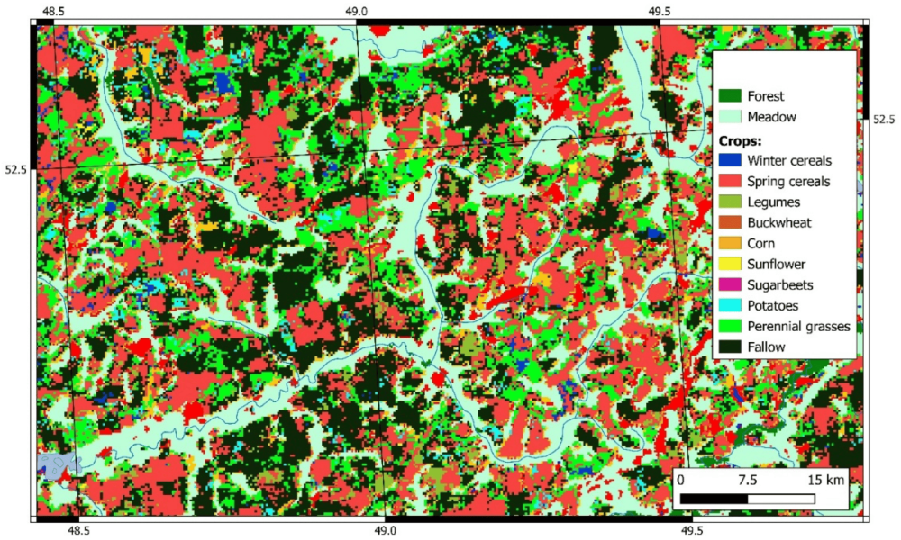
This project addresses one of the most pressing challenges in agricultural remote sensing: how to create reliable and generalizable models for crop type classification that remain effective across diverse geographies, seasons, and sensor platforms. Traditional crop mapping methods often fail when applied outside the specific region or season they were trained on, largely due to variations in soil reflectance, atmospheric conditions, crop management practices, and the differences between satellite sensors. This project seeks to overcome these limitations by focusing on the spectral signatures of crops, which are unique biochemical and physiological reflectance patterns observed throughout the growing season. By leveraging transfer learning and domain generalization strategies, the project aims to build robust models that can adapt to unseen environments while minimizing the need for costly and time-consuming ground truth data collection in every new region. The ultimate vision is to make crop mapping models more scalable, practical, and impactful for precision agriculture, food security monitoring, and climate resilience studies.

We combine advanced machine learning techniques with domain-specific agricultural knowledge. Using time-series satellite imagery, the spectral dynamics of crops such as wheat, rice, maize, and cotton are captured across different phenological stages. These temporal reflectance patterns are then processed into discriminative feature spaces that form the foundation for training crop classification models. Transfer learning is employed to reuse knowledge from existing datasets, while domain generalization approaches ensure the models remain resilient to shifts in location, season, or satellite sensor. For example, models trained on Sentinel-2 imagery in North American or European wheat-growing regions can be adapted to classify maize or wheat in South Asia, without retraining from scratch. Beyond just classification, the system also accounts for spectral overlap between crops and background vegetation, ensuring that the resulting crop maps are not only accurate but also temporally consistent. Such advancements are particularly critical for in-season mapping, where timely insights can directly inform government decisions, farmer advisory systems, and resource allocation during critical growth stages.

dgsb2

This work directly supports global priorities in agriculture, sustainability, and food systems management. By making crop mapping models more transferable and generalizable, the project reduces dependency on region-specific labeled datasets, lowering barriers for adoption in data-scarce regions. This opens new opportunities for governments and organizations in developing countries to monitor crop distribution and production in near-real time, even when they lack extensive ground-truth data infrastructure. Furthermore, the project has strong potential for integration with climate-smart farming initiatives, where understanding the spatial distribution of crops is essential for yield estimation, drought monitoring, and early warning systems. By advancing the scientific understanding of crop spectral signatures and embedding them into domain-robust machine learning frameworks, the project sets the stage for globally scalable crop monitoring pipelines. It empowers stakeholders at every level, from policymakers to individual farmers, by enabling accurate, adaptable, and timely crop intelligence derived from space-based observations.

Faculty

Students

  • Mamoona Qudsia
16

Monitoring Urban Sprawl & Urban Heat Islands Through Synthetic Aperture Radar

Monitoring Urban Sprawl & Urban Heat Islands Through Synthetic Aperture Radar

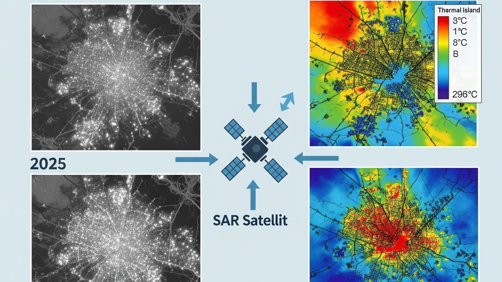
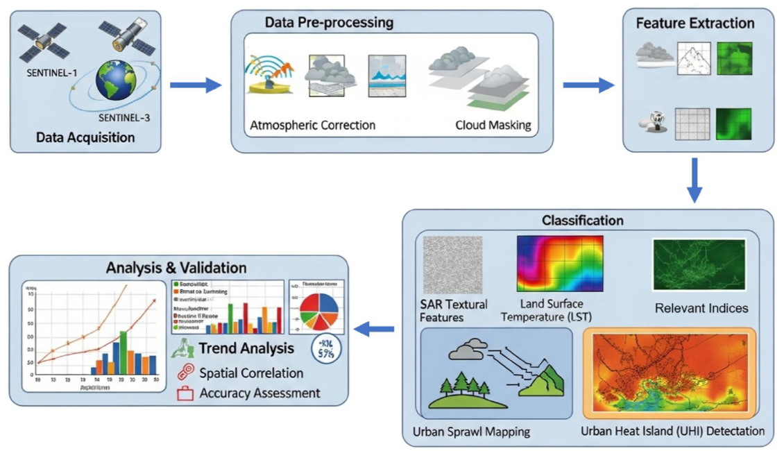
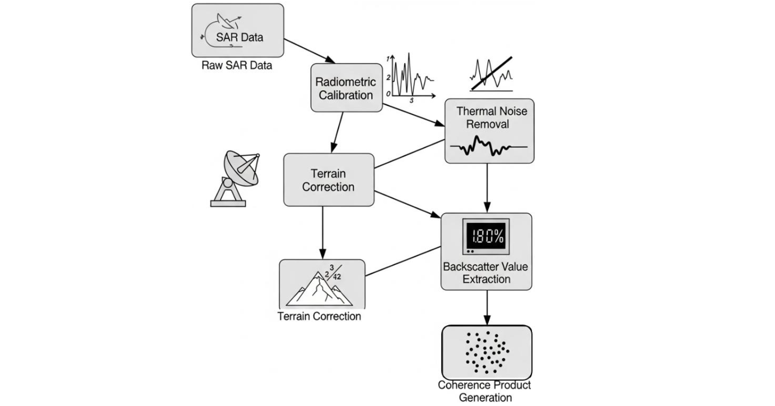
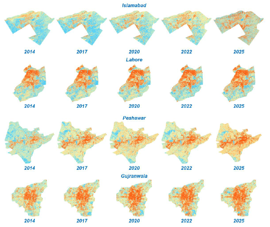
This project focuses on using advanced radar remote sensing techniques to study how rapid urban expansion alters land use and contributes to urban heat island (UHI) formation. With cities growing at unprecedented rates, conventional optical satellite imagery often faces limitations such as cloud cover, restricted revisit cycles, and dependence on daylight. Synthetic Aperture Radar (SAR) overcomes these constraints by offering consistent, high-resolution, all-weather imaging capabilities that are essential for monitoring dynamic urban landscapes. By applying polarization and coherence analyses, the system can differentiate between built-up areas, vegetation cover, and open land, thus allowing for precise mapping of sprawl patterns over time. This provides a reliable framework to assess the pace and direction of urban growth, while also generating crucial datasets for understanding the cascading effects of sprawl on microclimate and environmental balance.

A central aspect of this project lies in connecting land-use transformations with the intensification of UHIs, a phenomenon where built-up surfaces like concrete and asphalt absorb and retain heat, leading to elevated temperatures compared to surrounding rural areas. Through temporal SAR analysis, the project identifies subtle changes in surface structure, material properties, and urban density that directly contribute to heat accumulation. By correlating SAR-derived urban metrics with temperature and thermal data from complementary sources, a comprehensive model of UHI formation and evolution is developed. This enables the detection of critical hotspots where rising temperatures pose risks to public health, increase energy demands, and exacerbate environmental stresses such as poor air quality and reduced vegetation cover. The integration of SAR’s reliable temporal monitoring with environmental modeling creates a powerful tool to capture not just the physical expansion of cities but also the invisible thermal impacts embedded within that growth.

Beyond diagnostics, this work contributes actionable intelligence for policymakers, urban planners, and environmental managers. Insights derived from SAR-based sprawl and UHI monitoring can guide zoning policies, infrastructure investments, and the implementation of green interventions such as urban forests, reflective roofing, and sustainable drainage systems. By providing decision-makers with near-real-time and longitudinal data, the system ensures that urban development strategies can prioritize resilience, climate adaptation, and equitable resource allocation. Additionally, the methodology holds potential for global application, particularly in rapidly urbanizing regions where ground-based measurements are scarce or inconsistent. In sum, the project not only advances the technical frontiers of SAR-based environmental monitoring but also delivers practical solutions to one of the most pressing challenges of the 21st century: achieving sustainable urban development while mitigating the environmental and social costs of unchecked sprawl and intensifying heat islands.

Faculty

Students

  • Muhammad Ammar
  • Muhammad Dawood Rizwan
  • Usama Athar

15

Mapping Development & Consumption Through Nighttime Lights

Mapping Development & Consumption Through Nighttime Lights

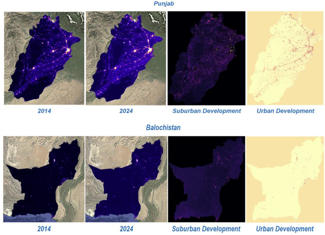
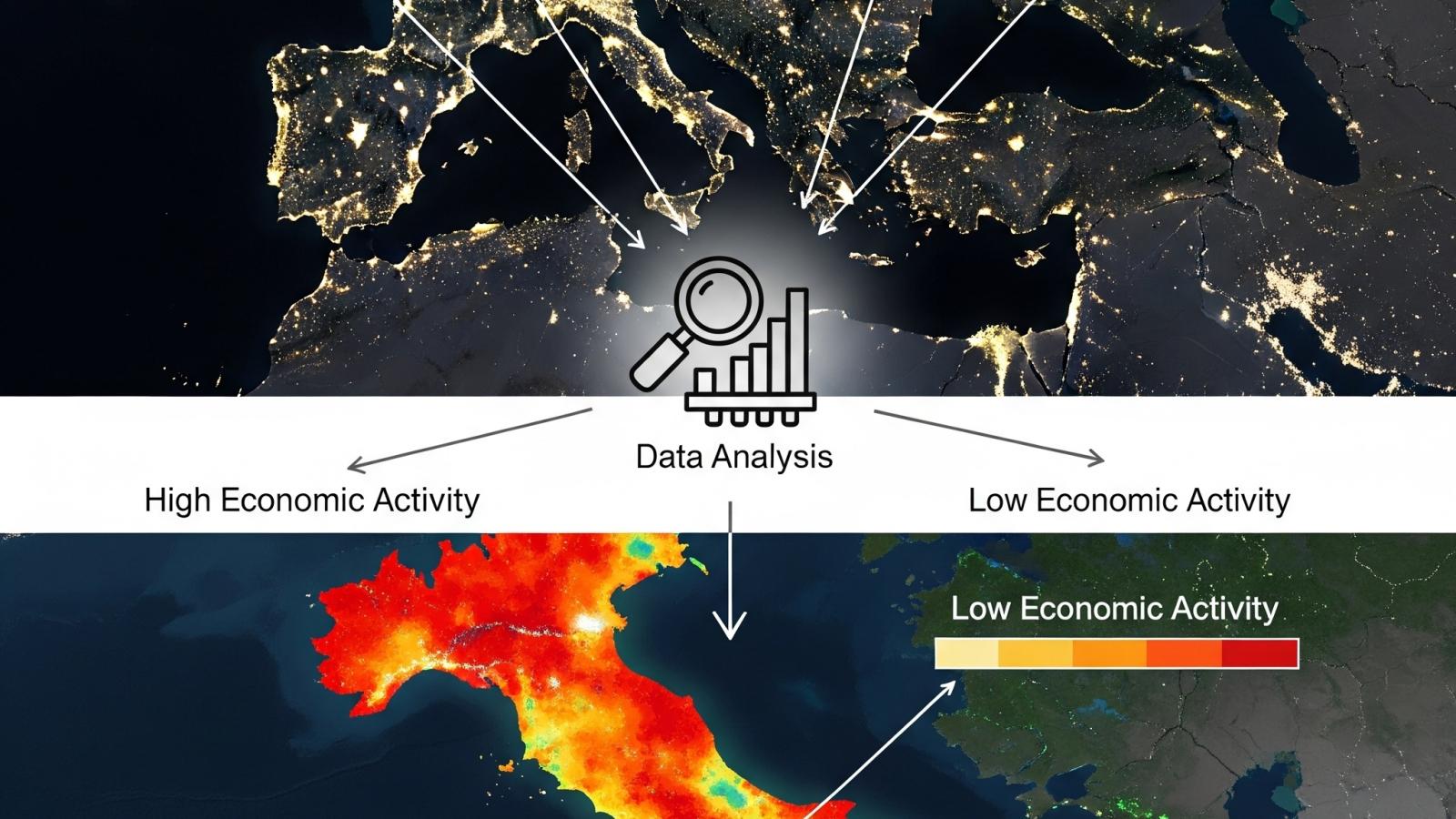
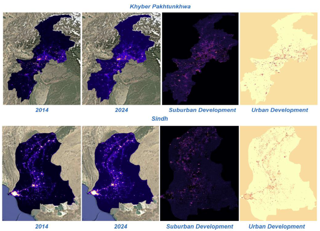
The aim of this project is to harness the power of satellite-derived nighttime light data to understand the relationship between electricity consumption, economic activity, and patterns of urbanization across regions. Over the past decade, nighttime light imagery captured by VIIRS (Visible Infrared Imaging Radiometer Suite) and DMSP-OLS (Defense Meteorological Satellite Program – Operational Linescan System) has emerged as a reliable proxy for human activity, industrial development, and socio-economic growth. This project builds upon that foundation by developing advanced methods for quantifying light intensity as an indicator of electricity consumption, infrastructure density, and population distribution. By integrating remote sensing with geospatial analytics, the project will identify regions of high and low consumption, map disparities in energy access, and track the pace of urban expansion, thereby providing an evidence-based understanding of development dynamics. Beyond simple correlations, the study will also focus on how variations in light intensity reveal patterns of inequality, such as rural underdevelopment and uneven distribution of resources, which are often missed in conventional economic surveys.

We use nighttime light intensity as a non-traditional but highly effective tool for economic mapping and monitoring GDP at regional and sub-regional scales. Traditional metrics of gross domestic product rely heavily on surveys, government reporting, and statistical models, which may be delayed, incomplete, or limited in spatial resolution. In contrast, nighttime lights offer continuous, objective, and globally comparable datasets that directly capture human activity patterns and their energy footprints. This project will create models that link calibrated light intensity with regional GDP values, industrial clusters, and service-sector hubs, thereby enabling near real-time monitoring of economic performance. Moreover, the analysis will extend to understanding how development is distributed geographically: are high levels of light concentrated in urban megacities, or do they reflect more dispersed growth across smaller towns and semi-urban regions? This perspective allows for a richer understanding of spatial inequality and economic resilience, particularly in developing economies where official statistics may lack granularity. The project also seeks to integrate nighttime light data with other spatial layers such as land use, road networks, and census datasets, enabling a multidimensional analysis of how energy consumption and development interact with infrastructure and population distribution.

This work project emphasizes its policy relevance and practical applications for sustainable planning and governance. Governments and urban planners often struggle with uneven electricity distribution, unmonitored urban sprawl, and limited insights into energy poverty. By leveraging nighttime light data, this project will provide actionable intelligence for identifying underserved regions, planning new infrastructure investments, and designing interventions for balanced regional growth. For instance, low-light intensity in certain areas may indicate inadequate electricity supply or socio-economic exclusion, while sudden spikes in lighting could reveal informal settlements or industrial zones expanding beyond planned limits. This information is critical for ensuring equitable energy distribution, supporting rural electrification efforts, and guiding urban growth policies. In addition, the framework developed in this project will serve as a scalable model for monitoring sustainable development goals (SDGs), particularly those related to affordable energy (SDG 7), sustainable cities (SDG 11), and economic growth (SDG 8). By linking remote sensing technology with socio-economic development, this work brings geospatial science and policymaking together, providing governments, researchers, and international organizations an innovative tool set for measuring progress and guiding strategies toward inclusive, sustainable development.

Faculty

Students

  • Navaal Iqbal
  • Ayesha Siddiqa
  • Amna Ahmed
  • Usama Athar
national workshop banner website

National Workshop & Technical Training Event On Digitization

A 2-day

National Workshop & Technical Training Event on

Digitization and Skill Development for Vocational Education in Pakistan

Date

18th – 19th August 2025

Venue

Seminar Hall, NUST SEECS, Sector H-12, Islamabad


About the Workshop and Training Event

Under the banner of the Ba-Ikhtiyar Jawan project, this two-day National Workshop & Technical Training event brings together academia, industry experts, and vocational education stakeholders to explore how digital innovation (AI, data-driven tools, and modern learning platforms) can strengthen Technical and Vocational Education and Training (TVET) in Pakistan.

  • Day 1 (Workshop | 18 August 2025) focuses on national-level dialogue and awareness-building around digitisation in vocational education, including how AI and Large Language Models (LLMs) can improve teaching, learning, assessment, and access, especially for rural and underserved communities.
  • Day 2 (Technical Training | 19 August 2025) translates those ideas into practical capacity-building through a structured training program on Auto-Electrician curriculum alignment and industry readiness, emphasizing competency-based learning, diagnostic tools, and curriculum digitization for modern job markets (including the Gulf region).
Gemini_Generated_Image_m5r0u9m5r0u9m5r0

Organizers

WhatsApp Image 2025-07-15 at 17.55.21_7fbb1bcc
Prof Dr. Muhammad Moazam Fraz

Professor & Associate Dean

SEECS, NUST

WhatsApp-Image-2025-07-15-at-15.59.50_fb344c58-300x275
Dr. Junaid Younus

Assistant Professor

SEECS, NUST

WhatsApp-Image-2025-07-15-at-15.59.50_196175f7-300x275
Dr. Muhammad Imran Malik

Associate Professor & HoD Dept. of Computer Science

SEECS, NUST

Partners

This event is funded by the German Academic Exchange Service (DAAD) under the project titled Ba-Ikhtiyar Jawan: Upscaling and Digitization of Vocational Education Curriculum.

Digital Presence and Online Visibility

Uploaded on Events in SEECS's Website
Click Here
Shared on NUST LinkedIn Page
Click Here

NUST: Facebook

SEECS: Facebook

MachVIS: Facebook

MachVIS: LinkedIn

ICESCO Chair: Twitter

ICESCO Chair: Facebook